Montealegre del Castillo geodata
Montealegre del Castillo (Castille-La Mancha) is a seat of a third-order administrative division; located in Spain in Europe/Madrid (GMT+2) time zone. With population of 2,327 people, there are 1987 cities with bigger population in this country. Compared to other cities in Spain, 83.3% of cities are located further ↑North; 74.5% of cities are located further ←West and 68.6% of cities have lower elevation than Montealegre del Castillo. Note1
Administrative division(s):
- Level 1: Castille-La Mancha
- Level 2: Provincia de Albacete
- Level 3: Montealegre del Castillo
Current local time in Montealegre del Castillo:
11:57 PM, ThursdayDifference from your time zone: hours


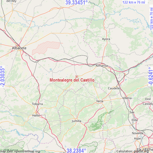
Montealegre del Castillo GPS coordinates[2]
38° 47' 18.816" North, 1° 19' 37.992" West
| Map corner | latitude | longitude |
|---|---|---|
| Upper-left | 39.33451°, | -2.03035° |
| Center: | 38.78856°, | -1.32722° |
| Lower-right: | 38.2384°, | -0.6241° |
| Map W x H: | 121.9×121.9 km | = 75.7×75.7mi |
| max Lat: | 43.74134° ⇑83.3% North |
| Montealegre del Castillo: | 38.78856° |
| min Lat: | ⇓16.7% South 27.64134° |
| min Long | Montealegre del | max Long |
| -18.00367° | -1.32722° | 4.2899° |
| W 74.5%⇐ | ⇒25.5% E |
Elevation
Elevation of Montealegre del Castillo is 803 m = 2635 ft, and this is 205 m = 673 ft above average elevation for this country.
| Max E: |
1682 m = 5518 ft | 31.4% |
| Montealegre del Castillo | 803 m 2635 ft | |
| Avg. | 598 m = 1962 ft | |
Min E: |
0 m = 0 ft | 68.6% |
See also: Spain elevation on elevation.city.
Geographical zone
Montealegre del Castillo is located in North temperate zone (between Tropic of Cancer and the Arctic Circle). Distance of this Northern Tropic circle is 1707 km =1060.7 mi to South.| Distance of | km | miles | from Montealegre del Castillo |
|---|---|---|---|
| North Pole | 5694.2 | 3538.2 | to North |
| Arctic Circle | 3088.3 | 1919 | to North |
| Tropic Cancer | 1707 | 1060.7 | to South |
| Equator | 4312.9 | 2679.9 | to South |


Nearby cities:
15 places around Montealegre del Castillo: (largest is in red/bold)
• Alatoz
34.2 km =21.3 mi,  355°
355°
• Albatana
29.6 km =18.4 mi,  214°
214°
• Almansa
21.9 km =13.6 mi,  65°
65°
• Alpera
20.7 km =12.9 mi,  23°
23°
• Bonete
9.4 km =5.8 mi,  348°
348°
• Carcelén
34.9 km =21.7 mi,  2°
2°
• Caudete
30.9 km =19.2 mi,  107°
107°
• Corral-Rubio
12.6 km =7.8 mi,  293°
293°
• Fuente-Álamo
14 km =8.7 mi,  220°
220°
• Higueruela
21.9 km =13.6 mi,  332°
332°
• Hoya-Gonzalo
27.4 km =17 mi,  313°
313°
• Jumilla
34.4 km =21.4 mi,  179°
179°
• Ontur
24.3 km =15.1 mi, 217°
• Pétrola
20.3 km =12.6 mi,  281°
281°
• Yecla
26.8 km =16.7 mi,  136°
136°
Sources, notices
• [Note1] Compared only with cities in Spain existing in our database
• [Src1] Map data: © OpenStreetMap contributors (CC-BY-SA)
• [Src2] Other city data from geonames.org with taken over terms of usage.
• [Src3] Geographical zone / Annual Mean Temperature by Robert A. Rohde @ Wikipedia
