Aliseda geodata
Aliseda (Extremadura) is a seat of a third-order administrative division; located in Spain in Europe/Madrid (GMT+2) time zone. With population of 1,894 people, there are 2231 cities with bigger population in this country. Compared to other cities in Spain, 77.6% of cities are located further ↑North; 92.8% of cities are located further →East and 73% of cities have higher elevation than Aliseda. Note1


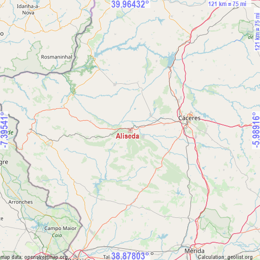
Aliseda GPS coordinates[2]
39° 25' 23.844" North, 6° 41' 32.208" West
| Map corner | latitude | longitude |
|---|---|---|
| Upper-left | 39.96432°, | -7.39541° |
| Center: | 39.42329°, | -6.69228° |
| Lower-right: | 38.87803°, | -5.98916° |
| Map W x H: | 120.8×120.8 km | = 75.1×75.1mi |
| max Lat: | 43.74134° ⇑77.6% North |
| Aliseda: | 39.42329° |
| min Lat: | ⇓22.4% South 27.64134° |
| min Long | Aliseda | max Long |
| -18.00367° | -6.69228° | 4.2899° |
| W 7.2%⇐ | ⇒92.8% E |
Elevation
Elevation of Aliseda is 333 m = 1093 ft, and this is 265 m = 869 ft below average elevation for this country.
| Max E: |
1682 m = 5518 ft | 73% |
| Avg. | 598 m = 1962 ft | |
| Aliseda | 333 m = 1093 ft | |
Min E: |
0 m = 0 ft | 27% |
See also: Spain elevation on elevation.city.
Geographical zone
Aliseda is located in North temperate zone (between Tropic of Cancer and the Arctic Circle). Distance of this Northern Tropic circle is 1777.5 km =1104.5 mi to South.| Distance of | km | miles | from Aliseda |
|---|---|---|---|
| North Pole | 5623.6 | 3494.3 | to North |
| Arctic Circle | 3017.7 | 1875.1 | to North |
| Tropic Cancer | 1777.5 | 1104.5 | to South |
| Equator | 4383.5 | 2723.8 | to South |


Nearby cities:
15 places around Aliseda: (largest is in red/bold)
• Arroyo de la Luz
11.6 km =7.2 mi,  53°
53°
• Brozas
22.3 km =13.9 mi,  340°
340°
• Casar de Cáceres
28 km =17.4 mi,  56°
56°
• Cáceres
28.1 km =17.5 mi,  77°
77°
• Garrovillas
34.2 km =21.3 mi,  20°
20°
• La Roca de la Sierra
34.9 km =21.7 mi,  179°
179°
• Malpartida de Cáceres
16.1 km =10 mi, 80°
• Mata de Alcántara
34.4 km =21.4 mi, 341°
• Membrío
33.1 km =20.6 mi,  290°
290°
• Navas del Madroño
22.5 km =14 mi,  8°
8°
• Puebla de Obando
28 km =17.4 mi,  168°
168°
• Salorino
27.8 km =17.3 mi,  283°
283°
• Valdesalor
30 km =18.6 mi,  99°
99°
• Villa del Rey
28.5 km =17.7 mi, 337°
• Villar del Rey
34.9 km =21.7 mi,  202°
202°
Sources, notices
• [Note1] Compared only with cities in Spain existing in our database
• [Src1] Map data: © OpenStreetMap contributors (CC-BY-SA)
• [Src2] Other city data from geonames.org with taken over terms of usage.
• [Src3] Geographical zone / Annual Mean Temperature by Robert A. Rohde @ Wikipedia
