Salorino geodata
Salorino (Extremadura) is a seat of a third-order administrative division; located in Spain in Europe/Madrid (GMT+2) time zone. With population of 796 people, there are 3218 cities with bigger population in this country. Compared to other cities in Spain, 77.1% of cities are located further ↑North; 94.3% of cities are located further →East and 73.6% of cities have higher elevation than Salorino. Note1


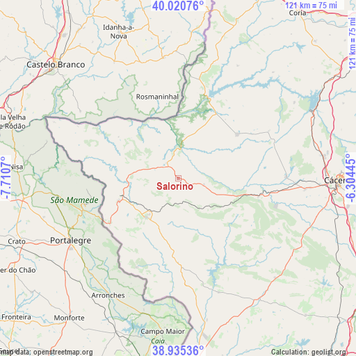
Salorino GPS coordinates[2]
39° 28' 48.648" North, 7° 0' 27.288" West
| Map corner | latitude | longitude |
|---|---|---|
| Upper-left | 40.02076°, | -7.7107° |
| Center: | 39.48018°, | -7.00758° |
| Lower-right: | 38.93536°, | -6.30445° |
| Map W x H: | 120.7×120.7 km | = 75×75mi |
| max Lat: | 43.74134° ⇑77.1% North |
| Salorino: | 39.48018° |
| min Lat: | ⇓22.9% South 27.64134° |
| min Long | Salorino | max Long |
| -18.00367° | -7.00758° | 4.2899° |
| W 5.7%⇐ | ⇒94.3% E |
Elevation
Elevation of Salorino is 323 m = 1060 ft, and this is 275 m = 902 ft below average elevation for this country.
| Max E: |
1682 m = 5518 ft | 73.6% |
| Avg. | 598 m = 1962 ft | |
| Salorino | 323 m = 1060 ft | |
Min E: |
0 m = 0 ft | 26.4% |
See also: Spain elevation on elevation.city.
Geographical zone
Salorino is located in North temperate zone (between Tropic of Cancer and the Arctic Circle). Distance of this Northern Tropic circle is 1783.9 km =1108.5 mi to South.| Distance of | km | miles | from Salorino |
|---|---|---|---|
| North Pole | 5617.3 | 3490.4 | to North |
| Arctic Circle | 3011.4 | 1871.2 | to North |
| Tropic Cancer | 1783.9 | 1108.5 | to South |
| Equator | 4389.8 | 2727.7 | to South |


Nearby cities:
15 places around Salorino: (largest is in red/bold)
• Alburquerque
28.8 km =17.9 mi,  179°
179°
• Alcántara
28.6 km =17.8 mi,  21°
21°
• Aliseda
27.8 km =17.3 mi,  103°
103°
• Arroyo de la Luz
36.4 km =22.6 mi,  89°
89°
• Brozas
24.6 km =15.3 mi,  53°
53°
• Carbajo
21.2 km =13.2 mi,  310°
310°
• La Codosera
33.4 km =20.8 mi,  205°
205°
• Mata de Alcántara
31 km =19.3 mi,  31°
31°
• Membrío
6.5 km =4 mi,  322°
322°
• Navas del Madroño
34.3 km =21.3 mi,  62°
62°
• Piedras Albas
34.5 km =21.4 mi,  11°
11°
• San Vicente de Alcántara
17.3 km =10.7 mi,  220°
220°
• Santiago de Alcántara
24.7 km =15.3 mi,  304°
304°
• Valencia de Alcántara
21.7 km =13.5 mi,  249°
249°
• Villa del Rey
25.6 km =15.9 mi,  38°
38°
Sources, notices
• [Note1] Compared only with cities in Spain existing in our database
• [Src1] Map data: © OpenStreetMap contributors (CC-BY-SA)
• [Src2] Other city data from geonames.org with taken over terms of usage.
• [Src3] Geographical zone / Annual Mean Temperature by Robert A. Rohde @ Wikipedia
