Membrío geodata
Membrío (Extremadura) is a populated place; located in Spain in Europe/Madrid (GMT+2) time zone. With population of 896 people, there are 3073 cities with bigger population in this country. Compared to other cities in Spain, 76.6% of cities are located further ↑North; 94.4% of cities are located further →East and 72.8% of cities have higher elevation than Membrío. Note1


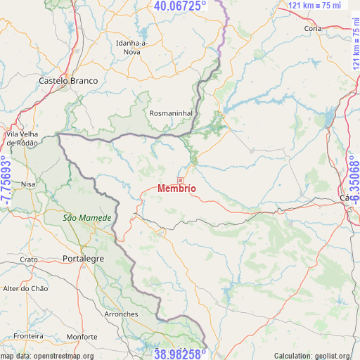
Membrío GPS coordinates[2]
39° 31' 37.308" North, 7° 3' 13.68" West
| Map corner | latitude | longitude |
|---|---|---|
| Upper-left | 40.06725°, | -7.75693° |
| Center: | 39.52703°, | -7.0538° |
| Lower-right: | 38.98258°, | -6.35068° |
| Map W x H: | 120.6×120.6 km | = 74.9×74.9mi |
| max Lat: | 43.74134° ⇑76.6% North |
| Membrío: | 39.52703° |
| min Lat: | ⇓23.4% South 27.64134° |
| min Long | Membrío | max Long |
| -18.00367° | -7.0538° | 4.2899° |
| W 5.6%⇐ | ⇒94.4% E |
Elevation
Elevation of Membrío is 336 m = 1102 ft, and this is 262 m = 860 ft below average elevation for this country.
| Max E: |
1682 m = 5518 ft | 72.8% |
| Avg. | 598 m = 1962 ft | |
| Membrío | 336 m = 1102 ft | |
Min E: |
0 m = 0 ft | 27.2% |
See also: Spain elevation on elevation.city.
Geographical zone
Membrío is located in North temperate zone (between Tropic of Cancer and the Arctic Circle). Distance of this Northern Tropic circle is 1789.1 km =1111.7 mi to South.| Distance of | km | miles | from Membrío |
|---|---|---|---|
| North Pole | 5612.1 | 3487.2 | to North |
| Arctic Circle | 3006.2 | 1868 | to North |
| Tropic Cancer | 1789.1 | 1111.7 | to South |
| Equator | 4395 | 2730.9 | to South |


Nearby cities:
15 places around Membrío: (largest is in red/bold)
• Alburquerque
34.3 km =21.3 mi,  172°
172°
• Alcántara
25.8 km =16 mi,  34°
34°
• Aliseda
33.1 km =20.6 mi,  110°
110°
• Brozas
25.5 km =15.8 mi,  68°
68°
• Carbajo
14.8 km =9.2 mi,  304°
304°
• Herrera de Alcántara
32.6 km =20.3 mi,  292°
292°
• La Codosera
36.8 km =22.9 mi,  196°
196°
• Mata de Alcántara
29.2 km =18.1 mi,  43°
43°
• Navas del Madroño
36 km =22.4 mi, 72°
• Piedras Albas
30.6 km =19 mi,  20°
20°
• Salorino
6.5 km =4 mi,  142°
142°
• San Vicente de Alcántara
19.8 km =12.3 mi, 201°
• Santiago de Alcántara
18.6 km =11.6 mi, 298°
• Valencia de Alcántara
20.8 km =12.9 mi,  231°
231°
• Villa del Rey
24.8 km =15.4 mi,  53°
53°
Sources, notices
• [Note1] Compared only with cities in Spain existing in our database
• [Src1] Map data: © OpenStreetMap contributors (CC-BY-SA)
• [Src2] Other city data from geonames.org with taken over terms of usage.
• [Src3] Geographical zone / Annual Mean Temperature by Robert A. Rohde @ Wikipedia
