Algar geodata
Algar (Andalusia) is a seat of a third-order administrative division; located in Spain in Europe/Madrid (GMT+2) time zone. With population of 1,637 people, there are 2379 cities with bigger population in this country. Compared to other cities in Spain, 97.6% of cities are located further ↑North; 81% of cities are located further →East and 80.7% of cities have higher elevation than Algar. Note1


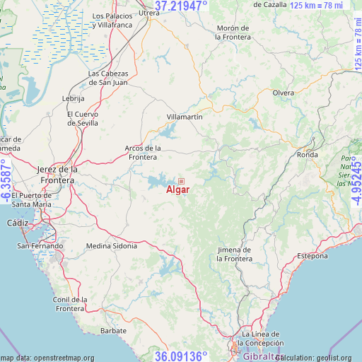
Algar GPS coordinates[2]
36° 39' 26.928" North, 5° 39' 20.088" West
| Map corner | latitude | longitude |
|---|---|---|
| Upper-left | 37.21947°, | -6.3587° |
| Center: | 36.65748°, | -5.65558° |
| Lower-right: | 36.09136°, | -4.95245° |
| Map W x H: | 125.4×125.4 km | = 77.9×77.9mi |
| max Lat: | 43.74134° ⇑97.6% North |
| Algar: | 36.65748° |
| min Lat: | ⇓2.4% South 27.64134° |
| min Long | Algar | max Long |
| -18.00367° | -5.65558° | 4.2899° |
| W 19%⇐ | ⇒81% E |
Elevation
Elevation of Algar is 208 m = 682 ft, and this is 390 m = 1280 ft below average elevation for this country.
| Max E: |
1682 m = 5518 ft | 80.7% |
| Avg. | 598 m = 1962 ft | |
| Algar | 208 m = 682 ft | |
Min E: |
0 m = 0 ft | 19.3% |
See also: Spain elevation on elevation.city.
Geographical zone
Algar is located in North temperate zone (between Tropic of Cancer and the Arctic Circle). Distance of this Northern Tropic circle is 1470 km =913.4 mi to South.| Distance of | km | miles | from Algar |
|---|---|---|---|
| North Pole | 5931.1 | 3685.4 | to North |
| Arctic Circle | 3325.2 | 2066.2 | to North |
| Tropic Cancer | 1470 | 913.4 | to South |
| Equator | 4075.9 | 2532.6 | to South |


Nearby cities:
15 places around Algar: (largest is in red/bold)
• Alcalá de los Gazules
22.6 km =14 mi,  195°
195°
• Arcos de la Frontera
17.3 km =10.7 mi,  306°
306°
• Benaocaz
21.4 km =13.3 mi,  76°
76°
• Bornos
19.4 km =12.1 mi,  335°
335°
• Cortes de la Frontera
28.3 km =17.6 mi,  99°
99°
• El Bosque
17.5 km =10.9 mi,  50°
50°
• Espera
27.6 km =17.1 mi,  330°
330°
• Grazalema
28 km =17.4 mi,  65°
65°
• Jimena de la Frontera
30.6 km =19 mi,  143°
143°
• Paterna de Rivera
24 km =14.9 mi,  231°
231°
• Prado del Rey
17 km =10.6 mi,  31°
31°
• San José del Valle
14 km =8.7 mi,  245°
245°
• Ubrique
18.8 km =11.7 mi, 83°
• Villaluenga del Rosario
24.4 km =15.2 mi, 79°
• Villamartín
22.5 km =14 mi,  2°
2°
Sources, notices
• [Note1] Compared only with cities in Spain existing in our database
• [Src1] Map data: © OpenStreetMap contributors (CC-BY-SA)
• [Src2] Other city data from geonames.org with taken over terms of usage.
• [Src3] Geographical zone / Annual Mean Temperature by Robert A. Rohde @ Wikipedia
