Villamartín geodata
Villamartín (Andalusia) is a seat of a third-order administrative division; located in Spain in Europe/Madrid (GMT+2) time zone. With population of 12,526 people, there are 727 cities with bigger population in this country. Compared to other cities in Spain, 96.3% of cities are located further ↑North; 80.8% of cities are located further →East and 84.4% of cities have higher elevation than Villamartín. Note1


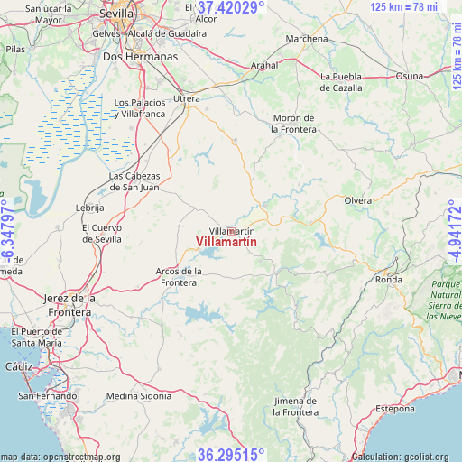
Villamartín GPS coordinates[2]
36° 51' 35.244" North, 5° 38' 41.46" West
| Map corner | latitude | longitude |
|---|---|---|
| Upper-left | 37.42029°, | -6.34797° |
| Center: | 36.85979°, | -5.64485° |
| Lower-right: | 36.29515°, | -4.94172° |
| Map W x H: | 125.1×125.1 km | = 77.7×77.7mi |
| max Lat: | 43.74134° ⇑96.3% North |
| Villamartín: | 36.85979° |
| min Lat: | ⇓3.7% South 27.64134° |
| min Long | Villamartín | max Long |
| -18.00367° | -5.64485° | 4.2899° |
| W 19.2%⇐ | ⇒80.8% E |
Elevation
Elevation of Villamartín is 149 m = 489 ft, and this is 449 m = 1473 ft below average elevation for this country.
| Max E: |
1682 m = 5518 ft | 84.4% |
| Avg. | 598 m = 1962 ft | |
| Villamartín | 149 m = 489 ft | |
Min E: |
0 m = 0 ft | 15.6% |
See also: Spain elevation on elevation.city.
Geographical zone
Villamartín is located in North temperate zone (between Tropic of Cancer and the Arctic Circle). Distance of this Northern Tropic circle is 1492.5 km =927.4 mi to South.| Distance of | km | miles | from Villamartín |
|---|---|---|---|
| North Pole | 5908.6 | 3671.4 | to North |
| Arctic Circle | 3302.7 | 2052.2 | to North |
| Tropic Cancer | 1492.5 | 927.4 | to South |
| Equator | 4098.4 | 2546.6 | to South |


Nearby cities:
15 places around Villamartín: (largest is in red/bold)
• Algar
22.5 km =14 mi,  182°
182°
• Algodonales
21.4 km =13.3 mi,  83°
83°
• Arcos de la Frontera
19.1 km =11.9 mi,  230°
230°
• Benaocaz
26.6 km =16.5 mi,  131°
131°
• Bornos
10.1 km =6.3 mi,  241°
241°
• Coripe
22.1 km =13.7 mi,  55°
55°
• El Bosque
16.8 km =10.4 mi, 132°
• El Coronil
24.5 km =15.2 mi,  2°
2°
• Espera
14.4 km =8.9 mi,  276°
276°
• Grazalema
27 km =16.8 mi,  114°
114°
• Montellano
16.4 km =10.2 mi,  23°
23°
• Prado del Rey
11.3 km =7 mi,  135°
135°
• Puerto Serrano
11.4 km =7.1 mi,  52°
52°
• Ubrique
26.9 km =16.7 mi, 138°
• Zahara
22.7 km =14.1 mi,  95°
95°
Sources, notices
• [Note1] Compared only with cities in Spain existing in our database
• [Src1] Map data: © OpenStreetMap contributors (CC-BY-SA)
• [Src2] Other city data from geonames.org with taken over terms of usage.
• [Src3] Geographical zone / Annual Mean Temperature by Robert A. Rohde @ Wikipedia
