Grazalema geodata
Grazalema (Andalusia) is a seat of a third-order administrative division; located in Spain in Europe/Madrid (GMT+2) time zone. With population of 2,160 people, there are 2075 cities with bigger population in this country. Compared to other cities in Spain, 97.1% of cities are located further ↑North; 77.1% of cities are located further →East and 72% of cities have lower elevation than Grazalema. Note1


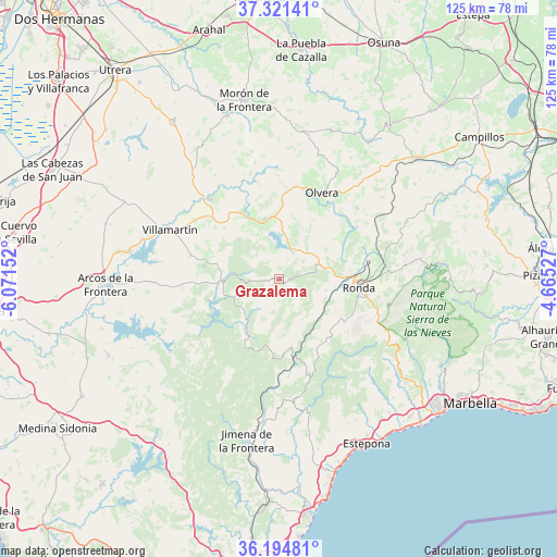
Grazalema GPS coordinates[2]
36° 45' 36.648" North, 5° 22' 6.204" West
| Map corner | latitude | longitude |
|---|---|---|
| Upper-left | 37.32141°, | -6.07152° |
| Center: | 36.76018°, | -5.36839° |
| Lower-right: | 36.19481°, | -4.66527° |
| Map W x H: | 125.3×125.3 km | = 77.9×77.9mi |
| max Lat: | 43.74134° ⇑97.1% North |
| Grazalema: | 36.76018° |
| min Lat: | ⇓2.9% South 27.64134° |
| min Long | Grazalema | max Long |
| -18.00367° | -5.36839° | 4.2899° |
| W 22.9%⇐ | ⇒77.1% E |
Elevation
Elevation of Grazalema is 827 m = 2713 ft, and this is 229 m = 751 ft above average elevation for this country.
| Max E: |
1682 m = 5518 ft | 28% |
| Grazalema | 827 m 2713 ft | |
| Avg. | 598 m = 1962 ft | |
Min E: |
0 m = 0 ft | 72% |
See also: Spain elevation on elevation.city.
Geographical zone
Grazalema is located in North temperate zone (between Tropic of Cancer and the Arctic Circle). Distance of this Northern Tropic circle is 1481.4 km =920.5 mi to South.| Distance of | km | miles | from Grazalema |
|---|---|---|---|
| North Pole | 5919.7 | 3678.3 | to North |
| Arctic Circle | 3313.8 | 2059.1 | to North |
| Tropic Cancer | 1481.4 | 920.5 | to South |
| Equator | 4087.3 | 2539.7 | to South |


Nearby cities:
15 places around Grazalema: (largest is in red/bold)
• Algodonales
13.8 km =8.6 mi,  346°
346°
• Atajate
17.2 km =10.7 mi,  140°
140°
• Benaocaz
8.2 km =5.1 mi,  215°
215°
• Benaoján
11.3 km =7 mi,  113°
113°
• Cortes de la Frontera
16.1 km =10 mi,  171°
171°
• El Bosque
12.2 km =7.6 mi,  269°
269°
• El Gastor
11.3 km =7 mi,  20°
20°
• Jimera de Líbar
14.7 km =9.1 mi,  145°
145°
• Montecorto
8.8 km =5.5 mi,  45°
45°
• Montejaque
10.9 km =6.8 mi,  103°
103°
• Prado del Rey
17 km =10.6 mi,  280°
280°
• Ronda
18 km =11.2 mi, 96°
• Ubrique
11.5 km =7.1 mi, 217°
• Villaluenga del Rosario
7.3 km =4.5 mi,  192°
192°
• Zahara
9.2 km =5.7 mi, 347°
Sources, notices
• [Note1] Compared only with cities in Spain existing in our database
• [Src1] Map data: © OpenStreetMap contributors (CC-BY-SA)
• [Src2] Other city data from geonames.org with taken over terms of usage.
• [Src3] Geographical zone / Annual Mean Temperature by Robert A. Rohde @ Wikipedia
