El Bosque geodata
El Bosque (Andalusia) is a populated place; located in Spain in Europe/Madrid (GMT+2) time zone. With population of 1,984 people, there are 2183 cities with bigger population in this country. Compared to other cities in Spain, 97.1% of cities are located further ↑North; 78.8% of cities are located further →East and 75.7% of cities have higher elevation than El Bosque. Note1


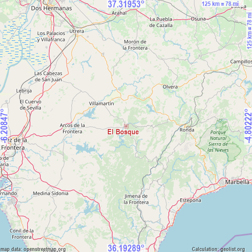
El Bosque GPS coordinates[2]
36° 45' 29.808" North, 5° 30' 19.26" West
| Map corner | latitude | longitude |
|---|---|---|
| Upper-left | 37.31953°, | -6.20847° |
| Center: | 36.75828°, | -5.50535° |
| Lower-right: | 36.19289°, | -4.80222° |
| Map W x H: | 125.3×125.3 km | = 77.9×77.9mi |
| max Lat: | 43.74134° ⇑97.1% North |
| El Bosque: | 36.75828° |
| min Lat: | ⇓2.9% South 27.64134° |
| min Long | El Bosque | max Long |
| -18.00367° | -5.50535° | 4.2899° |
| W 21.2%⇐ | ⇒78.8% E |
Elevation
Elevation of El Bosque is 289 m = 948 ft, and this is 309 m = 1014 ft below average elevation for this country.
| Max E: |
1682 m = 5518 ft | 75.7% |
| Avg. | 598 m = 1962 ft | |
| El Bosque | 289 m = 948 ft | |
Min E: |
0 m = 0 ft | 24.3% |
See also: Spain elevation on elevation.city.
Geographical zone
El Bosque is located in North temperate zone (between Tropic of Cancer and the Arctic Circle). Distance of this Northern Tropic circle is 1481.2 km =920.4 mi to South.| Distance of | km | miles | from El Bosque |
|---|---|---|---|
| North Pole | 5919.9 | 3678.5 | to North |
| Arctic Circle | 3314 | 2059.2 | to North |
| Tropic Cancer | 1481.2 | 920.4 | to South |
| Equator | 4087.1 | 2539.6 | to South |


Nearby cities:
15 places around El Bosque: (largest is in red/bold)
• Algar
17.5 km =10.9 mi,  230°
230°
• Algodonales
16.2 km =10.1 mi,  33°
33°
• Benaocaz
9.8 km =6.1 mi,  130°
130°
• Bornos
22.3 km =13.9 mi,  286°
286°
• Cortes de la Frontera
21.4 km =13.3 mi,  137°
137°
• El Gastor
19.4 km =12.1 mi,  56°
56°
• Grazalema
12.2 km =7.6 mi,  89°
89°
• Montecorto
19.5 km =12.1 mi,  70°
70°
• Montejaque
22.9 km =14.2 mi,  95°
95°
• Prado del Rey
5.6 km =3.5 mi,  305°
305°
• Puerto Serrano
18.5 km =11.5 mi,  349°
349°
• Ubrique
10.4 km =6.5 mi,  149°
149°
• Villaluenga del Rosario
12.7 km =7.9 mi,  122°
122°
• Villamartín
16.8 km =10.4 mi, 312°
• Zahara
13.7 km =8.5 mi,  47°
47°
Sources, notices
• [Note1] Compared only with cities in Spain existing in our database
• [Src1] Map data: © OpenStreetMap contributors (CC-BY-SA)
• [Src2] Other city data from geonames.org with taken over terms of usage.
• [Src3] Geographical zone / Annual Mean Temperature by Robert A. Rohde @ Wikipedia
