Arcos de la Frontera geodata
Arcos de la Frontera (Andalusia) is a seat of a third-order administrative division; located in Spain in Europe/Madrid (GMT+2) time zone. With population of 31,210 people, there are 288 cities with bigger population in this country. Compared to other cities in Spain, 97.2% of cities are located further ↑North; 83.4% of cities are located further →East and 84.8% of cities have higher elevation than Arcos de la Frontera. Note1
Administrative division(s):
- Level 1: Andalusia
- Level 2: Provincia de Cádiz
- Level 3: Arcos de la Frontera


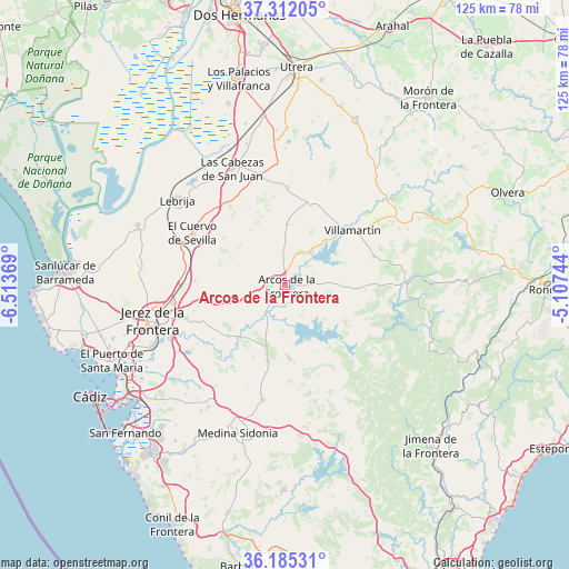
Arcos de la Frontera GPS coordinates[2]
36° 45' 2.7" North, 5° 48' 38.016" West
| Map corner | latitude | longitude |
|---|---|---|
| Upper-left | 37.31205°, | -6.51369° |
| Center: | 36.75075°, | -5.81056° |
| Lower-right: | 36.18531°, | -5.10744° |
| Map W x H: | 125.3×125.3 km | = 77.9×77.9mi |
| max Lat: | 43.74134° ⇑97.2% North |
| Arcos de la Frontera: | 36.75075° |
| min Lat: | ⇓2.8% South 27.64134° |
| min Long | Arcos de la Fro | max Long |
| -18.00367° | -5.81056° | 4.2899° |
| W 16.6%⇐ | ⇒83.4% E |
Elevation
Elevation of Arcos de la Frontera is 144 m = 472 ft, and this is 454 m = 1490 ft below average elevation for this country.
| Max E: |
1682 m = 5518 ft | 84.8% |
| Avg. | 598 m = 1962 ft | |
| Arcos de la Frontera | 144 m = 472 ft | |
Min E: |
0 m = 0 ft | 15.2% |
See also: Spain elevation on elevation.city.
Geographical zone
Arcos de la Frontera is located in North temperate zone (between Tropic of Cancer and the Arctic Circle). Distance of this Northern Tropic circle is 1480.4 km =919.9 mi to South.| Distance of | km | miles | from Arcos de la Frontera |
|---|---|---|---|
| North Pole | 5920.8 | 3679 | to North |
| Arctic Circle | 3314.9 | 2059.8 | to North |
| Tropic Cancer | 1480.4 | 919.9 | to South |
| Equator | 4086.3 | 2539.1 | to South |


Nearby cities:
15 places around Arcos de la Frontera: (largest is in red/bold)
• Alcalá de los Gazules
33 km =20.5 mi,  166°
166°
• Algar
17.3 km =10.7 mi,  126°
126°
• Bornos
9.4 km =5.8 mi,  38°
38°
• El Bosque
27.2 km =16.9 mi,  88°
88°
• El Cuervo
23.2 km =14.4 mi,  299°
299°
• Espera
13.8 km =8.6 mi,  1°
1°
• Jerez de la Frontera
29.9 km =18.6 mi,  256°
256°
• Las Cabezas de San Juan
28.3 km =17.6 mi,  336°
336°
• Lebrija
30.2 km =18.8 mi,  308°
308°
• Paterna de Rivera
25.9 km =16.1 mi,  190°
190°
• Prado del Rey
23 km =14.3 mi,  79°
79°
• Puerto Serrano
30.5 km =19 mi,  51°
51°
• San José del Valle
16.2 km =10.1 mi,  176°
176°
• Ubrique
33.5 km =20.8 mi,  104°
104°
• Villamartín
19.1 km =11.9 mi, 50°
Sources, notices
• [Note1] Compared only with cities in Spain existing in our database
• [Src1] Map data: © OpenStreetMap contributors (CC-BY-SA)
• [Src2] Other city data from geonames.org with taken over terms of usage.
• [Src3] Geographical zone / Annual Mean Temperature by Robert A. Rohde @ Wikipedia
