Bornos geodata
Bornos (Andalusia) is a populated place; located in Spain in Europe/Madrid (GMT+2) time zone. With population of 8,105 people, there are 927 cities with bigger population in this country. Compared to other cities in Spain, 96.7% of cities are located further ↑North; 82.4% of cities are located further →East and 84.1% of cities have higher elevation than Bornos. Note1
Administrative division(s):
- Level 1: Andalusia
- Level 2: Provincia de Cádiz
- Level 3: Jerez de la Frontera


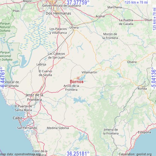
Bornos GPS coordinates[2]
36° 49' 0.372" North, 5° 44' 40.128" West
| Map corner | latitude | longitude |
|---|---|---|
| Upper-left | 37.37759°, | -6.44761° |
| Center: | 36.81677°, | -5.74448° |
| Lower-right: | 36.25181°, | -5.04136° |
| Map W x H: | 125.2×125.2 km | = 77.8×77.8mi |
| max Lat: | 43.74134° ⇑96.7% North |
| Bornos: | 36.81677° |
| min Lat: | ⇓3.3% South 27.64134° |
| min Long | Bornos | max Long |
| -18.00367° | -5.74448° | 4.2899° |
| W 17.6%⇐ | ⇒82.4% E |
Elevation
Elevation of Bornos is 154 m = 505 ft, and this is 444 m = 1457 ft below average elevation for this country.
| Max E: |
1682 m = 5518 ft | 84.1% |
| Avg. | 598 m = 1962 ft | |
| Bornos | 154 m = 505 ft | |
Min E: |
0 m = 0 ft | 15.9% |
See also: Spain elevation on elevation.city.
Geographical zone
Bornos is located in North temperate zone (between Tropic of Cancer and the Arctic Circle). Distance of this Northern Tropic circle is 1487.7 km =924.4 mi to South.| Distance of | km | miles | from Bornos |
|---|---|---|---|
| North Pole | 5913.4 | 3674.4 | to North |
| Arctic Circle | 3307.5 | 2055.2 | to North |
| Tropic Cancer | 1487.7 | 924.4 | to South |
| Equator | 4093.6 | 2543.6 | to South |


Nearby cities:
15 places around Bornos: (largest is in red/bold)
• Algar
19.4 km =12.1 mi,  155°
155°
• Algodonales
31 km =19.3 mi,  76°
76°
• Arcos de la Frontera
9.4 km =5.8 mi,  218°
218°
• El Bosque
22.3 km =13.9 mi,  106°
106°
• El Coronil
30.8 km =19.1 mi,  18°
18°
• El Cuervo
26.4 km =16.4 mi,  278°
278°
• Espera
8.4 km =5.2 mi,  319°
319°
• Las Cabezas de San Juan
25.4 km =15.8 mi, 316°
• Montellano
25.1 km =15.6 mi,  37°
37°
• Prado del Rey
17.1 km =10.6 mi,  100°
100°
• Puerto Serrano
21.4 km =13.3 mi,  56°
56°
• San José del Valle
24 km =14.9 mi,  191°
191°
• Ubrique
30.8 km =19.1 mi,  120°
120°
• Villamartín
10.1 km =6.3 mi, 61°
• Zahara
31.5 km =19.6 mi,  85°
85°
Sources, notices
• [Note1] Compared only with cities in Spain existing in our database
• [Src1] Map data: © OpenStreetMap contributors (CC-BY-SA)
• [Src2] Other city data from geonames.org with taken over terms of usage.
• [Src3] Geographical zone / Annual Mean Temperature by Robert A. Rohde @ Wikipedia
