Espera geodata
Espera (Andalusia) is a seat of a third-order administrative division; located in Spain in Europe/Madrid (GMT+2) time zone. With population of 3,810 people, there are 1514 cities with bigger population in this country. Compared to other cities in Spain, 96.2% of cities are located further ↑North; 83.3% of cities are located further →East and 84% of cities have higher elevation than Espera. Note1


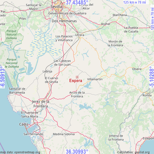
Espera GPS coordinates[2]
36° 52' 28.056" North, 5° 48' 21.6" West
| Map corner | latitude | longitude |
|---|---|---|
| Upper-left | 37.43485°, | -6.50913° |
| Center: | 36.87446°, | -5.806° |
| Lower-right: | 36.30993°, | -5.10288° |
| Map W x H: | 125.1×125.1 km | = 77.7×77.7mi |
| max Lat: | 43.74134° ⇑96.2% North |
| Espera: | 36.87446° |
| min Lat: | ⇓3.8% South 27.64134° |
| min Long | Espera | max Long |
| -18.00367° | -5.806° | 4.2899° |
| W 16.7%⇐ | ⇒83.3% E |
Elevation
Elevation of Espera is 155 m = 509 ft, and this is 443 m = 1453 ft below average elevation for this country.
| Max E: |
1682 m = 5518 ft | 84% |
| Avg. | 598 m = 1962 ft | |
| Espera | 155 m = 509 ft | |
Min E: |
0 m = 0 ft | 16% |
See also: Spain elevation on elevation.city.
Geographical zone
Espera is located in North temperate zone (between Tropic of Cancer and the Arctic Circle). Distance of this Northern Tropic circle is 1494.1 km =928.4 mi to South.| Distance of | km | miles | from Espera |
|---|---|---|---|
| North Pole | 5907 | 3670.4 | to North |
| Arctic Circle | 3301.1 | 2051.2 | to North |
| Tropic Cancer | 1494.1 | 928.4 | to South |
| Equator | 4100.1 | 2547.7 | to South |


Nearby cities:
15 places around Espera: (largest is in red/bold)
• Algar
27.6 km =17.1 mi,  150°
150°
• Arcos de la Frontera
13.8 km =8.6 mi,  181°
181°
• Bornos
8.4 km =5.2 mi,  139°
139°
• El Bosque
29.7 km =18.5 mi,  115°
115°
• El Coronil
27.4 km =17 mi,  33°
33°
• El Cuervo
20.8 km =12.9 mi,  263°
263°
• Las Cabezas de San Juan
17 km =10.6 mi,  315°
315°
• Lebrija
24.5 km =15.2 mi,  282°
282°
• Los Molares
32.4 km =20.1 mi,  13°
13°
• Montellano
24.8 km =15.4 mi,  57°
57°
• Prado del Rey
24.3 km =15.1 mi,  113°
113°
• Puerto Serrano
24 km =14.9 mi,  77°
77°
• San José del Valle
29.9 km =18.6 mi, 178°
• Trebujena
32.9 km =20.4 mi,  269°
269°
• Villamartín
14.4 km =8.9 mi,  96°
96°
Sources, notices
• [Note1] Compared only with cities in Spain existing in our database
• [Src1] Map data: © OpenStreetMap contributors (CC-BY-SA)
• [Src2] Other city data from geonames.org with taken over terms of usage.
• [Src3] Geographical zone / Annual Mean Temperature by Robert A. Rohde @ Wikipedia
