Pozo-Cañada geodata
Pozo-Cañada (Castille-La Mancha) is a populated place; located in Spain in Europe/Madrid (GMT+2) time zone. With population of 2,681 people, there are 1824 cities with bigger population in this country. Compared to other cities in Spain, 83.2% of cities are located further ↑North; 70.1% of cities are located further ←West and 69.5% of cities have lower elevation than Pozo-Cañada. Note1
Administrative division(s):
- Level 1: Castille-La Mancha
- Level 2: Provincia de Albacete
- Level 3: Chinchilla de Monte-Aragón


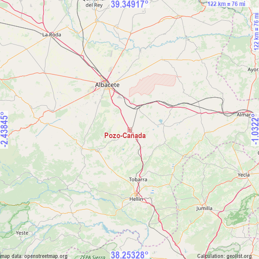
Pozo-Cañada GPS coordinates[2]
38° 48' 11.988" North, 1° 44' 7.152" West
| Map corner | latitude | longitude |
|---|---|---|
| Upper-left | 39.34917°, | -2.43845° |
| Center: | 38.80333°, | -1.73532° |
| Lower-right: | 38.25328°, | -1.0322° |
| Map W x H: | 121.9×121.9 km | = 75.7×75.7mi |
| max Lat: | 43.74134° ⇑83.2% North |
| Pozo-Cañada: | 38.80333° |
| min Lat: | ⇓16.8% South 27.64134° |
| min Long | Pozo-Cañada | max Long |
| -18.00367° | -1.73532° | 4.2899° |
| W 70.1%⇐ | ⇒29.9% E |
Elevation
Elevation of Pozo-Cañada is 811 m = 2661 ft, and this is 213 m = 699 ft above average elevation for this country.
| Max E: |
1682 m = 5518 ft | 30.5% |
| Pozo-Cañada | 811 m 2661 ft | |
| Avg. | 598 m = 1962 ft | |
Min E: |
0 m = 0 ft | 69.5% |
See also: Spain elevation on elevation.city.
Geographical zone
Pozo-Cañada is located in North temperate zone (between Tropic of Cancer and the Arctic Circle). Distance of this Northern Tropic circle is 1708.6 km =1061.7 mi to South.| Distance of | km | miles | from Pozo-Cañada |
|---|---|---|---|
| North Pole | 5692.5 | 3537.2 | to North |
| Arctic Circle | 3086.6 | 1917.9 | to North |
| Tropic Cancer | 1708.6 | 1061.7 | to South |
| Equator | 4314.5 | 2680.9 | to South |


Nearby cities:
15 places around Pozo-Cañada: (largest is in red/bold)
• Albacete
23.7 km =14.7 mi,  333°
333°
• Albatana
31.8 km =19.8 mi,  144°
144°
• Alcadozo
27.3 km =17 mi,  231°
231°
• Chinchilla de Monte Aragón
13.1 km =8.1 mi,  5°
5°
• Corral-Rubio
24.1 km =15 mi,  81°
81°
• Fuente-Álamo
29.1 km =18.1 mi,  114°
114°
• Hellín
32.7 km =20.3 mi,  174°
174°
• Higueruela
30.9 km =19.2 mi,  54°
54°
• Hoya-Gonzalo
23.1 km =14.4 mi,  41°
41°
• Ontur
29.4 km =18.3 mi, 135°
• Peñas de San Pedro
24.8 km =15.4 mi,  250°
250°
• Pozohondo
17.8 km =11.1 mi,  239°
239°
• Pozuelo
31.7 km =19.7 mi,  271°
271°
• Pétrola
15.7 km =9.8 mi, 80°
• Tobarra
23.8 km =14.8 mi, 170°
Sources, notices
• [Note1] Compared only with cities in Spain existing in our database
• [Src1] Map data: © OpenStreetMap contributors (CC-BY-SA)
• [Src2] Other city data from geonames.org with taken over terms of usage.
• [Src3] Geographical zone / Annual Mean Temperature by Robert A. Rohde @ Wikipedia
