Villarquemado geodata
Villarquemado (Aragon) is a seat of a third-order administrative division; located in Spain in Europe/Madrid (GMT+2) time zone. With population of 943 people, there are 3022 cities with bigger population in this country. Compared to other cities in Spain, 61.5% of cities are located further ↑North; 75.1% of cities are located further ←West and 88.2% of cities have lower elevation than Villarquemado. Note1


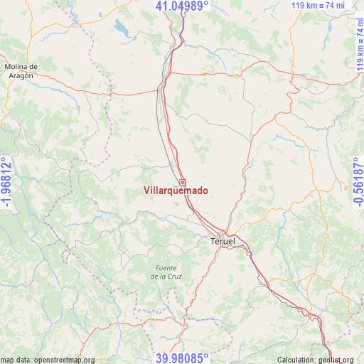
Villarquemado GPS coordinates[2]
40° 31' 3" North, 1° 15' 54" West
| Map corner | latitude | longitude |
|---|---|---|
| Upper-left | 41.04989°, | -1.96812° |
| Center: | 40.5175°, | -1.265° |
| Lower-right: | 39.98085°, | -0.56187° |
| Map W x H: | 118.9×118.9 km | = 73.9×73.9mi |
| max Lat: | 43.74134° ⇑61.5% North |
| Villarquemado: | 40.5175° |
| min Lat: | ⇓38.5% South 27.64134° |
| min Long | Villarquemado | max Long |
| -18.00367° | -1.265° | 4.2899° |
| W 75.1%⇐ | ⇒24.9% E |
Elevation
Elevation of Villarquemado is 1001 m = 3284 ft, and this is 403 m = 1322 ft above average elevation for this country.
| Max E: |
1682 m = 5518 ft | 11.8% |
| Villarquemado | 1001 m 3284 ft | |
| Avg. | 598 m = 1962 ft | |
Min E: |
0 m = 0 ft | 88.2% |
See also: Spain elevation on elevation.city.
Geographical zone
Villarquemado is located in North temperate zone (between Tropic of Cancer and the Arctic Circle). Distance of this Northern Tropic circle is 1899.2 km =1180.1 mi to South.| Distance of | km | miles | from Villarquemado |
|---|---|---|---|
| North Pole | 5501.9 | 3418.7 | to North |
| Arctic Circle | 2896.1 | 1799.6 | to North |
| Tropic Cancer | 1899.2 | 1180.1 | to South |
| Equator | 4505.1 | 2799.3 | to South |


Nearby cities:
15 places around Villarquemado: (largest is in red/bold)
• Aguatón
17.3 km =10.7 mi,  8°
8°
• Alba
13.2 km =8.2 mi,  328°
328°
• Albarracín
19.4 km =12.1 mi,  231°
231°
• Alfambra
19.9 km =12.4 mi,  80°
80°
• Almohaja
17.5 km =10.9 mi,  303°
303°
• Argente
20.9 km =13 mi,  24°
24°
• Camañas
17.6 km =10.9 mi,  37°
37°
• Cella
7.4 km =4.6 mi,  194°
194°
• Cuevas Labradas
19.5 km =12.1 mi,  111°
111°
• Gea de Albarracín
13.8 km =8.6 mi,  210°
210°
• Monterde de Albarracín
19.3 km =12 mi,  263°
263°
• Peralejos
19.9 km =12.4 mi,  100°
100°
• Pozondón
18 km =11.2 mi,  285°
285°
• Santa Eulalia
6.9 km =4.3 mi,  323°
323°
• Singra
15.8 km =9.8 mi,  345°
345°
Sources, notices
• [Note1] Compared only with cities in Spain existing in our database
• [Src1] Map data: © OpenStreetMap contributors (CC-BY-SA)
• [Src2] Other city data from geonames.org with taken over terms of usage.
• [Src3] Geographical zone / Annual Mean Temperature by Robert A. Rohde @ Wikipedia
