Ribeira geodata
Ribeira (Galicia) is a populated place; located in Spain in Europe/Madrid (GMT+2) time zone. With population of 27,518 people, there are 338 cities with bigger population in this country. Compared to other cities in Spain, 92% of cities are located further ↓South; 97.2% of cities are located further →East and 90.1% of cities have higher elevation than Ribeira. Note1


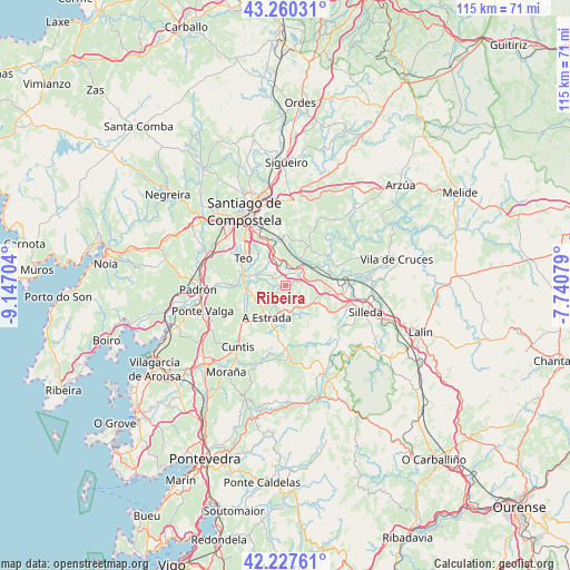
Ribeira GPS coordinates[2]
42° 44' 45.996" North, 8° 26' 38.112" West
| Map corner | latitude | longitude |
|---|---|---|
| Upper-left | 43.26031°, | -9.14704° |
| Center: | 42.74611°, | -8.44392° |
| Lower-right: | 42.22761°, | -7.74079° |
| Map W x H: | 114.8×114.8 km | = 71.3×71.3mi |
| max Lat: | 43.74134° ⇑8% North |
| Ribeira: | 42.74611° |
| min Lat: | ⇓92% South 27.64134° |
| min Long | Ribeira | max Long |
| -18.00367° | -8.44392° | 4.2899° |
| W 2.8%⇐ | ⇒97.2% E |
Elevation
Elevation of Ribeira is 64 m = 210 ft, and this is 534 m = 1752 ft below average elevation for this country.
| Max E: |
1682 m = 5518 ft | 90.1% |
| Avg. | 598 m = 1962 ft | |
| Ribeira | 64 m = 210 ft | |
Min E: |
0 m = 0 ft | 9.9% |
See also: Spain elevation on elevation.city.
Geographical zone
Ribeira is located in North temperate zone (between Tropic of Cancer and the Arctic Circle). Distance of this Northern Tropic circle is 2147 km =1334.1 mi to South.| Distance of | km | miles | from Ribeira |
|---|---|---|---|
| North Pole | 5254.1 | 3264.7 | to North |
| Arctic Circle | 2648.3 | 1645.6 | to North |
| Tropic Cancer | 2147 | 1334.1 | to South |
| Equator | 4752.9 | 2953.3 | to South |


Nearby cities:
15 places around Ribeira: (largest is in red/bold)
• A Estrada
7.3 km =4.5 mi,  209°
209°
• Amés
24.6 km =15.3 mi,  315°
315°
• Caldas de Reis
22.6 km =14 mi,  225°
225°
• Catoira
24.4 km =15.2 mi,  249°
249°
• Cuntis
15.8 km =9.8 mi,  217°
217°
• Forcarei
18.7 km =11.6 mi,  156°
156°
• Moraña
24.6 km =15.3 mi, 207°
• Padrón
17.7 km =11 mi,  267°
267°
• Rois
21.4 km =13.3 mi,  275°
275°
• Santiago de Compostela
17.1 km =10.6 mi,  330°
330°
• Silleda
17.1 km =10.6 mi,  109°
109°
• Teo
4.6 km =2.9 mi, 275°
• Touro
17.5 km =10.9 mi,  39°
39°
• Valga
16.9 km =10.5 mi, 251°
• Vedra
4.4 km =2.7 mi, 323°
Sources, notices
• [Note1] Compared only with cities in Spain existing in our database
• [Src1] Map data: © OpenStreetMap contributors (CC-BY-SA)
• [Src2] Other city data from geonames.org with taken over terms of usage.
• [Src3] Geographical zone / Annual Mean Temperature by Robert A. Rohde @ Wikipedia
