Tresviso geodata
Tresviso (Cantabria) is a seat of a third-order administrative division; located in Spain in Europe/Madrid (GMT+2) time zone. In our database, there are 6762 cities with bigger population. Compared to other cities in Spain, 97.1% of cities are located further ↓South; 68.3% of cities are located further →East and 78.8% of cities have lower elevation than Tresviso. Note1


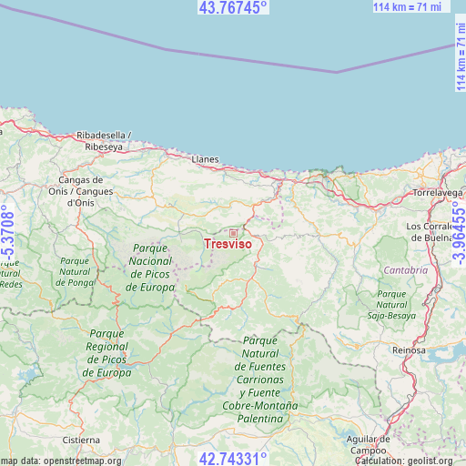
Tresviso GPS coordinates[2]
43° 15' 27.108" North, 4° 40' 3.648" West
| Map corner | latitude | longitude |
|---|---|---|
| Upper-left | 43.76745°, | -5.3708° |
| Center: | 43.25753°, | -4.66768° |
| Lower-right: | 42.74331°, | -3.96455° |
| Map W x H: | 113.9×113.9 km | = 70.8×70.8mi |
| max Lat: | 43.74134° ⇑2.9% North |
| Tresviso: | 43.25753° |
| min Lat: | ⇓97.1% South 27.64134° |
| min Long | Tresviso | max Long |
| -18.00367° | -4.66768° | 4.2899° |
| W 31.7%⇐ | ⇒68.3% E |
Elevation
Elevation of Tresviso is 886 m = 2907 ft, and this is 288 m = 945 ft above average elevation for this country.
| Max E: |
1682 m = 5518 ft | 21.2% |
| Tresviso | 886 m 2907 ft | |
| Avg. | 598 m = 1962 ft | |
Min E: |
0 m = 0 ft | 78.8% |
See also: Spain elevation on elevation.city.
Geographical zone
Tresviso is located in North temperate zone (between Tropic of Cancer and the Arctic Circle). Distance of this Northern Tropic circle is 2203.9 km =1369.4 mi to South.| Distance of | km | miles | from Tresviso |
|---|---|---|---|
| North Pole | 5197.3 | 3229.5 | to North |
| Arctic Circle | 2591.4 | 1610.2 | to North |
| Tropic Cancer | 2203.9 | 1369.4 | to South |
| Equator | 4809.8 | 2988.7 | to South |


Nearby cities:
15 places around Tresviso: (largest is in red/bold)
• Amieva
33 km =20.5 mi,  267°
267°
• Barrio de la Iglesia
36.4 km =22.6 mi,  67°
67°
• Cabezón de Liébana
15.6 km =9.7 mi,  151°
151°
• Cabezón de la Sal
35.4 km =22 mi,  80°
80°
• Camaleño
12.1 km =7.5 mi,  190°
190°
• Carreña
15.9 km =9.9 mi,  294°
294°
• Comillas
33.6 km =20.9 mi,  64°
64°
• Llanes
19.4 km =12.1 mi,  338°
338°
• Onís
25.8 km =16 mi, 290°
• Oseja de Sajambre
32.9 km =20.4 mi,  245°
245°
• Posada de Valdeón
23.7 km =14.7 mi,  240°
240°
• Potes
12.1 km =7.5 mi,  161°
161°
• Ruente
32.4 km =20.1 mi,  89°
89°
• San Vicente de la Barquera
25.9 km =16.1 mi, 56°
• Triollo
37 km =23 mi,  181°
181°
Sources, notices
• [Note1] Compared only with cities in Spain existing in our database
• [Src1] Map data: © OpenStreetMap contributors (CC-BY-SA)
• [Src2] Other city data from geonames.org with taken over terms of usage.
• [Src3] Geographical zone / Annual Mean Temperature by Robert A. Rohde @ Wikipedia
