Ruente geodata
Ruente (Cantabria) is a seat of a third-order administrative division; located in Spain in Europe/Madrid (GMT+2) time zone. With population of 992 people, there are 2960 cities with bigger population in this country. Compared to other cities in Spain, 97.1% of cities are located further ↓South; 63.4% of cities are located further →East and 81.9% of cities have higher elevation than Ruente. Note1


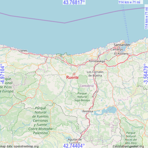
Ruente GPS coordinates[2]
43° 15' 29.736" North, 4° 16' 4.476" West
| Map corner | latitude | longitude |
|---|---|---|
| Upper-left | 43.76817°, | -4.97104° |
| Center: | 43.25826°, | -4.26791° |
| Lower-right: | 42.74404°, | -3.56479° |
| Map W x H: | 113.9×113.9 km | = 70.8×70.8mi |
| max Lat: | 43.74134° ⇑2.9% North |
| Ruente: | 43.25826° |
| min Lat: | ⇓97.1% South 27.64134° |
| min Long | Ruente | max Long |
| -18.00367° | -4.26791° | 4.2899° |
| W 36.6%⇐ | ⇒63.4% E |
Elevation
Elevation of Ruente is 189 m = 620 ft, and this is 409 m = 1342 ft below average elevation for this country.
| Max E: |
1682 m = 5518 ft | 81.9% |
| Avg. | 598 m = 1962 ft | |
| Ruente | 189 m = 620 ft | |
Min E: |
0 m = 0 ft | 18.1% |
See also: Spain elevation on elevation.city.
Geographical zone
Ruente is located in North temperate zone (between Tropic of Cancer and the Arctic Circle). Distance of this Northern Tropic circle is 2203.9 km =1369.4 mi to South.| Distance of | km | miles | from Ruente |
|---|---|---|---|
| North Pole | 5197.2 | 3229.4 | to North |
| Arctic Circle | 2591.3 | 1610.2 | to North |
| Tropic Cancer | 2203.9 | 1369.4 | to South |
| Equator | 4809.9 | 2988.7 | to South |


Nearby cities:
15 places around Ruente: (largest is in red/bold)
• Arenas de Iguña
19.7 km =12.2 mi,  115°
115°
• Barrio de la Iglesia
13.7 km =8.5 mi,  5°
5°
• Bárcena de Pie de Concha
22.6 km =14 mi,  130°
130°
• Cabezón de la Sal
6.1 km =3.8 mi,  25°
25°
• Cartes
17.8 km =11.1 mi,  64°
64°
• Comillas
14.3 km =8.9 mi,  352°
352°
• Los Corrales de Buelna
15.8 km =9.8 mi,  87°
87°
• Luzmela
6.4 km =4 mi,  48°
48°
• Molledo
21.9 km =13.6 mi, 123°
• Polanco
24.8 km =15.4 mi, 55°
• Puente Viesgo
24.7 km =15.3 mi,  79°
79°
• Reocín
16.7 km =10.4 mi, 57°
• San Vicente de la Barquera
17.7 km =11 mi,  322°
322°
• Santillana
19.4 km =12.1 mi,  41°
41°
• Torrelavega
20.5 km =12.7 mi, 60°
Sources, notices
• [Note1] Compared only with cities in Spain existing in our database
• [Src1] Map data: © OpenStreetMap contributors (CC-BY-SA)
• [Src2] Other city data from geonames.org with taken over terms of usage.
• [Src3] Geographical zone / Annual Mean Temperature by Robert A. Rohde @ Wikipedia
