Comillas geodata
Comillas (Cantabria) is a populated place; located in Spain in Europe/Madrid (GMT+2) time zone. With population of 2,439 people, there are 1918 cities with bigger population in this country. Compared to other cities in Spain, 98.7% of cities are located further ↓South; 63.7% of cities are located further →East and 94.9% of cities have higher elevation than Comillas. Note1


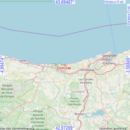
Comillas GPS coordinates[2]
43° 23' 9.708" North, 4° 17' 29.832" West
| Map corner | latitude | longitude |
|---|---|---|
| Upper-left | 43.89487°, | -4.99474° |
| Center: | 43.38603°, | -4.29162° |
| Lower-right: | 42.87289°, | -3.58849° |
| Map W x H: | 113.6×113.6 km | = 70.6×70.6mi |
| max Lat: | 43.74134° ⇑1.3% North |
| Comillas: | 43.38603° |
| min Lat: | ⇓98.7% South 27.64134° |
| min Long | Comillas | max Long |
| -18.00367° | -4.29162° | 4.2899° |
| W 36.3%⇐ | ⇒63.7% E |
Elevation
Elevation of Comillas is 25 m = 82 ft, and this is 573 m = 1880 ft below average elevation for this country.
| Max E: |
1682 m = 5518 ft | 94.9% |
| Avg. | 598 m = 1962 ft | |
| Comillas | 25 m = 82 ft | |
Min E: |
0 m = 0 ft | 5.1% |
See also: Spain elevation on elevation.city.
Geographical zone
Comillas is located in North temperate zone (between Tropic of Cancer and the Arctic Circle). Distance of this Northern Tropic circle is 2218.2 km =1378.3 mi to South.| Distance of | km | miles | from Comillas |
|---|---|---|---|
| North Pole | 5183 | 3220.6 | to North |
| Arctic Circle | 2577.1 | 1601.3 | to North |
| Tropic Cancer | 2218.2 | 1378.3 | to South |
| Equator | 4824.1 | 2997.6 | to South |


Nearby cities:
15 places around Comillas: (largest is in red/bold)
• Arenas de Iguña
30 km =18.6 mi,  138°
138°
• Barrio de la Iglesia
3.4 km =2.1 mi,  99°
99°
• Cabezón de la Sal
9.8 km =6.1 mi,  152°
152°
• Cartes
19.2 km =11.9 mi,  110°
110°
• Los Corrales de Buelna
22.3 km =13.9 mi,  127°
127°
• Luzmela
12 km =7.5 mi, 145°
• Miengo
24.1 km =15 mi,  78°
78°
• Polanco
22.2 km =13.8 mi,  90°
90°
• Puente Viesgo
27.9 km =17.3 mi, 110°
• Reocín
16.8 km =10.4 mi, 108°
• Ruente
14.3 km =8.9 mi,  172°
172°
• San Vicente de la Barquera
8.7 km =5.4 mi,  269°
269°
• Santillana
14.8 km =9.2 mi, 88°
• Suances
20.7 km =12.9 mi, 75°
• Torrelavega
20.1 km =12.5 mi, 101°
Sources, notices
• [Note1] Compared only with cities in Spain existing in our database
• [Src1] Map data: © OpenStreetMap contributors (CC-BY-SA)
• [Src2] Other city data from geonames.org with taken over terms of usage.
• [Src3] Geographical zone / Annual Mean Temperature by Robert A. Rohde @ Wikipedia
