San Vicente de la Barquera geodata
San Vicente de la Barquera (Cantabria) is a seat of a third-order administrative division; located in Spain in Europe/Madrid (GMT+2) time zone. With population of 4,475 people, there are 1389 cities with bigger population in this country. Compared to other cities in Spain, 98.7% of cities are located further ↓South; 64.9% of cities are located further →East and 98.4% of cities have higher elevation than San Vicente de la Barquera. Note1
Administrative division(s):
- Level 1: Cantabria
- Level 2: Provincia de Cantabria
- Level 3: San Vicente de la Barquera
Current local time in San Vicente de la Barquera:
11:54 PM, ThursdayDifference from your time zone: hours


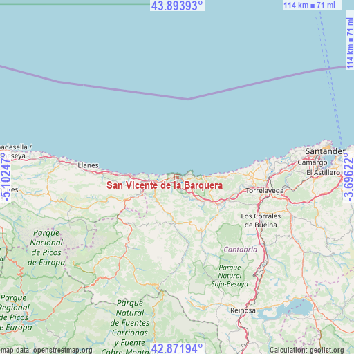
San Vicente de la Barquera GPS coordinates[2]
43° 23' 6.324" North, 4° 23' 57.624" West
| Map corner | latitude | longitude |
|---|---|---|
| Upper-left | 43.89393°, | -5.10247° |
| Center: | 43.38509°, | -4.39934° |
| Lower-right: | 42.87194°, | -3.69622° |
| Map W x H: | 113.6×113.6 km | = 70.6×70.6mi |
| max Lat: | 43.74134° ⇑1.3% North |
| San Vicente de la Barquera: | 43.38509° |
| min Lat: | ⇓98.7% South 27.64134° |
| min Long | San Vicente de | max Long |
| -18.00367° | -4.39934° | 4.2899° |
| W 35.1%⇐ | ⇒64.9% E |
Elevation
Elevation of San Vicente de la Barquera is 10 m = 33 ft, and this is 588 m = 1929 ft below average elevation for this country.
| Max E: |
1682 m = 5518 ft | 98.4% |
| Avg. | 598 m = 1962 ft | |
| San Vicente de la Barquera | 10 m = 33 ft | |
Min E: |
0 m = 0 ft | 1.6% |
See also: Spain elevation on elevation.city.
Geographical zone
San Vicente de la Barquera is located in North temperate zone (between Tropic of Cancer and the Arctic Circle). Distance of this Northern Tropic circle is 2218.1 km =1378.3 mi to South.| Distance of | km | miles | from San Vicente de la Barquera |
|---|---|---|---|
| North Pole | 5183.1 | 3220.6 | to North |
| Arctic Circle | 2577.2 | 1601.4 | to North |
| Tropic Cancer | 2218.1 | 1378.3 | to South |
| Equator | 4824 | 2997.5 | to South |


Nearby cities:
15 places around San Vicente de la Barquera: (largest is in red/bold)
• Barrio de la Iglesia
12 km =7.5 mi,  92°
92°
• Cabezón de Liébana
31.3 km =19.4 mi,  207°
207°
• Cabezón de la Sal
15.8 km =9.8 mi,  122°
122°
• Cartes
27.5 km =17.1 mi,  103°
103°
• Comillas
8.7 km =5.4 mi, 89°
• Llanes
29 km =18 mi,  277°
277°
• Los Corrales de Buelna
29.7 km =18.5 mi, 117°
• Luzmela
18.3 km =11.4 mi, 122°
• Polanco
30.9 km =19.2 mi, 89°
• Reocín
25.2 km =15.7 mi, 101°
• Ruente
17.7 km =11 mi,  142°
142°
• Santillana
23.5 km =14.6 mi, 88°
• Suances
29.3 km =18.2 mi,  79°
79°
• Torrelavega
28.7 km =17.8 mi, 97°
• Tresviso
25.9 km =16.1 mi,  236°
236°
Sources, notices
• [Note1] Compared only with cities in Spain existing in our database
• [Src1] Map data: © OpenStreetMap contributors (CC-BY-SA)
• [Src2] Other city data from geonames.org with taken over terms of usage.
• [Src3] Geographical zone / Annual Mean Temperature by Robert A. Rohde @ Wikipedia
