Beuda geodata
Beuda (Catalonia) is a seat of a third-order administrative division; located in Spain in Europe/Madrid (GMT+2) time zone. With population of 77 people, there are 6173 cities with bigger population in this country. Compared to other cities in Spain, 80.3% of cities are located further ↓South; 97.2% of cities are located further ←West and 72.8% of cities have higher elevation than Beuda. Note1


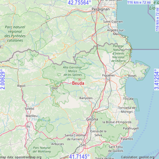
Beuda GPS coordinates[2]
42° 14' 13.992" North, 2° 42' 33.912" East
| Map corner | latitude | longitude |
|---|---|---|
| Upper-left | 42.75564°, | 2.00629° |
| Center: | 42.23722°, | 2.70942° |
| Lower-right: | 41.7145°, | 3.41254° |
| Map W x H: | 115.8×115.8 km | = 72×72mi |
| max Lat: | 43.74134° ⇑19.7% North |
| Beuda: | 42.23722° |
| min Lat: | ⇓80.3% South 27.64134° |
| min Long | Beuda | max Long |
| -18.00367° | 2.70942° | 4.2899° |
| W 97.2%⇐ | ⇒2.8% E |
Elevation
Elevation of Beuda is 336 m = 1102 ft, and this is 262 m = 860 ft below average elevation for this country.
| Max E: |
1682 m = 5518 ft | 72.8% |
| Avg. | 598 m = 1962 ft | |
| Beuda | 336 m = 1102 ft | |
Min E: |
0 m = 0 ft | 27.2% |
See also: Spain elevation on elevation.city.
Geographical zone
Beuda is located in North temperate zone (between Tropic of Cancer and the Arctic Circle). Distance of this Northern Tropic circle is 2090.4 km =1298.9 mi to South.| Distance of | km | miles | from Beuda |
|---|---|---|---|
| North Pole | 5310.7 | 3299.9 | to North |
| Arctic Circle | 2704.8 | 1680.7 | to North |
| Tropic Cancer | 2090.4 | 1298.9 | to South |
| Equator | 4696.3 | 2918.1 | to South |


Nearby cities:
15 places around Beuda: (largest is in red/bold)
• Argelaguer
6.1 km =3.8 mi,  246°
246°
• Besalú
4.3 km =2.7 mi,  190°
190°
• Cabanelles
9.1 km =5.7 mi,  94°
94°
• Cistella
11.9 km =7.4 mi,  72°
72°
• Crespià
9.6 km =6 mi,  128°
128°
• Esponellà
10.8 km =6.7 mi,  136°
136°
• Lladó
8.7 km =5.4 mi,  82°
82°
• Montagut
9.3 km =5.8 mi,  265°
265°
• Navata
12.6 km =7.8 mi,  96°
96°
• Sales de Llierca
4.9 km =3 mi,  264°
264°
• Sant Ferriol
5.4 km =3.4 mi,  220°
220°
• Sant Jaume de Llierca
8 km =5 mi, 253°
• Sant Llorenç de la Muga
11.3 km =7 mi,  35°
35°
• Sant Miquel de Campmajor
11.7 km =7.3 mi, 190°
• Tortellà
6.3 km =3.9 mi, 266°
Sources, notices
• [Note1] Compared only with cities in Spain existing in our database
• [Src1] Map data: © OpenStreetMap contributors (CC-BY-SA)
• [Src2] Other city data from geonames.org with taken over terms of usage.
• [Src3] Geographical zone / Annual Mean Temperature by Robert A. Rohde @ Wikipedia
