Terrer geodata
Terrer (Aragon) is a seat of a third-order administrative division; located in Spain in Europe/Madrid (GMT+2) time zone. With population of 515 people, there are 3831 cities with bigger population in this country. Compared to other cities in Spain, 55.8% of cities are located further ↓South; 70.4% of cities are located further ←West and 56.9% of cities have higher elevation than Terrer. Note1


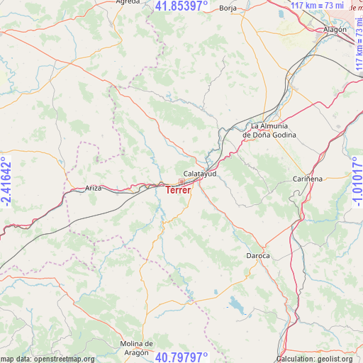
Terrer GPS coordinates[2]
41° 19' 41.196" North, 1° 42' 47.844" West
| Map corner | latitude | longitude |
|---|---|---|
| Upper-left | 41.85397°, | -2.41642° |
| Center: | 41.32811°, | -1.71329° |
| Lower-right: | 40.79797°, | -1.01017° |
| Map W x H: | 117.4×117.4 km | = 72.9×72.9mi |
| max Lat: | 43.74134° ⇑44.2% North |
| Terrer: | 41.32811° |
| min Lat: | ⇓55.8% South 27.64134° |
| min Long | Terrer | max Long |
| -18.00367° | -1.71329° | 4.2899° |
| W 70.4%⇐ | ⇒29.6% E |
Elevation
Elevation of Terrer is 567 m = 1860 ft, and this is 31 m = 102 ft below average elevation for this country.
| Max E: |
1682 m = 5518 ft | 56.9% |
| Avg. | 598 m = 1962 ft | |
| Terrer | 567 m = 1860 ft | |
Min E: |
0 m = 0 ft | 43.1% |
See also: Spain elevation on elevation.city.
Geographical zone
Terrer is located in North temperate zone (between Tropic of Cancer and the Arctic Circle). Distance of this Northern Tropic circle is 1989.3 km =1236.1 mi to South.| Distance of | km | miles | from Terrer |
|---|---|---|---|
| North Pole | 5411.8 | 3362.7 | to North |
| Arctic Circle | 2805.9 | 1743.5 | to North |
| Tropic Cancer | 1989.3 | 1236.1 | to South |
| Equator | 4595.3 | 2855.4 | to South |


Nearby cities:
15 places around Terrer: (largest is in red/bold)
• Aniñon
13 km =8.1 mi,  3°
3°
• Ateca
6.7 km =4.2 mi,  272°
272°
• Bubierca
11.8 km =7.3 mi,  262°
262°
• Calatayud
6.5 km =4 mi,  64°
64°
• Carenas
9 km =5.6 mi,  231°
231°
• Castejón de las Armas
8.4 km =5.2 mi, 255°
• Cervera de la Cañada
11.8 km =7.3 mi,  350°
350°
• Maluenda
9.3 km =5.8 mi,  118°
118°
• Moros
12.3 km =7.6 mi,  308°
308°
• Munébrega
8.5 km =5.3 mi,  175°
175°
• Olvés
11.3 km =7 mi,  150°
150°
• Paracuellos de Jiloca
6.3 km =3.9 mi,  104°
104°
• Torralba de Ribota
10.3 km =6.4 mi,  13°
13°
• Valtorres
4 km =2.5 mi,  214°
214°
• Velilla de Jiloca
10.9 km =6.8 mi, 122°
Sources, notices
• [Note1] Compared only with cities in Spain existing in our database
• [Src1] Map data: © OpenStreetMap contributors (CC-BY-SA)
• [Src2] Other city data from geonames.org with taken over terms of usage.
• [Src3] Geographical zone / Annual Mean Temperature by Robert A. Rohde @ Wikipedia
