Ateca geodata
Ateca (Aragon) is a seat of a third-order administrative division; located in Spain in Europe/Madrid (GMT+2) time zone. With population of 2,055 people, there are 2127 cities with bigger population in this country. Compared to other cities in Spain, 55.9% of cities are located further ↓South; 69.6% of cities are located further ←West and 54.6% of cities have higher elevation than Ateca. Note1


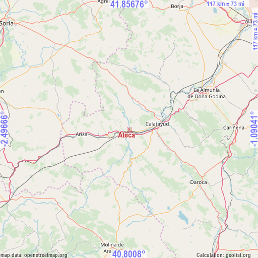
Ateca GPS coordinates[2]
41° 19' 51.312" North, 1° 47' 36.708" West
| Map corner | latitude | longitude |
|---|---|---|
| Upper-left | 41.85676°, | -2.49666° |
| Center: | 41.33092°, | -1.79353° |
| Lower-right: | 40.8008°, | -1.09041° |
| Map W x H: | 117.4×117.4 km | = 72.9×72.9mi |
| max Lat: | 43.74134° ⇑44.1% North |
| Ateca: | 41.33092° |
| min Lat: | ⇓55.9% South 27.64134° |
| min Long | Ateca | max Long |
| -18.00367° | -1.79353° | 4.2899° |
| W 69.6%⇐ | ⇒30.4% E |
Elevation
Elevation of Ateca is 600 m = 1969 ft, and this is 2 m = 7 ft above average elevation for this country.
| Max E: |
1682 m = 5518 ft | 54.6% |
| Ateca | 600 m 1969 ft | |
| Avg. | 598 m = 1962 ft | |
Min E: |
0 m = 0 ft | 45.4% |
See also: Spain elevation on elevation.city.
Geographical zone
Ateca is located in North temperate zone (between Tropic of Cancer and the Arctic Circle). Distance of this Northern Tropic circle is 1989.6 km =1236.3 mi to South.| Distance of | km | miles | from Ateca |
|---|---|---|---|
| North Pole | 5411.5 | 3362.5 | to North |
| Arctic Circle | 2805.6 | 1743.3 | to North |
| Tropic Cancer | 1989.6 | 1236.3 | to South |
| Equator | 4595.6 | 2855.6 | to South |


Nearby cities:
15 places around Ateca: (largest is in red/bold)
• Alhama de Aragón
9.2 km =5.7 mi,  245°
245°
• Bubierca
5.3 km =3.3 mi, 250°
• Calatayud
12.8 km =8 mi,  78°
78°
• Carenas
5.9 km =3.7 mi,  183°
183°
• Castejón de las Armas
2.8 km =1.7 mi,  211°
211°
• Cervera de la Cañada
12.3 km =7.6 mi,  23°
23°
• Contamina
10.7 km =6.6 mi, 254°
• Godojos
9.1 km =5.7 mi,  220°
220°
• Ibdes
13.1 km =8.1 mi,  194°
194°
• Moros
8 km =5 mi,  338°
338°
• Munébrega
11.4 km =7.1 mi,  140°
140°
• Paracuellos de Jiloca
12.9 km =8 mi,  98°
98°
• Terrer
6.7 km =4.2 mi,  92°
92°
• Valtorres
5.7 km =3.5 mi,  129°
129°
• Villalengua
12.3 km =7.6 mi, 341°
Sources, notices
• [Note1] Compared only with cities in Spain existing in our database
• [Src1] Map data: © OpenStreetMap contributors (CC-BY-SA)
• [Src2] Other city data from geonames.org with taken over terms of usage.
• [Src3] Geographical zone / Annual Mean Temperature by Robert A. Rohde @ Wikipedia
