Orcajo geodata
Orcajo (Aragon) is a seat of a third-order administrative division; located in Spain in Europe/Madrid (GMT+2) time zone. With population of 36 people, there are 6610 cities with bigger population in this country. Compared to other cities in Spain, 51.2% of cities are located further ↓South; 73% of cities are located further ←West and 82.9% of cities have lower elevation than Orcajo. Note1


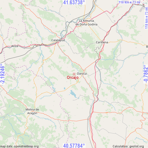
Orcajo GPS coordinates[2]
41° 6' 35.1" North, 1° 29' 21.588" West
| Map corner | latitude | longitude |
|---|---|---|
| Upper-left | 41.63738°, | -2.19246° |
| Center: | 41.10975°, | -1.48933° |
| Lower-right: | 40.57784°, | -0.7862° |
| Map W x H: | 117.8×117.8 km | = 73.2×73.2mi |
| max Lat: | 43.74134° ⇑48.8% North |
| Orcajo: | 41.10975° |
| min Lat: | ⇓51.2% South 27.64134° |
| min Long | Orcajo | max Long |
| -18.00367° | -1.48933° | 4.2899° |
| W 73%⇐ | ⇒27% E |
Elevation
Elevation of Orcajo is 927 m = 3041 ft, and this is 329 m = 1079 ft above average elevation for this country.
| Max E: |
1682 m = 5518 ft | 17.1% |
| Orcajo | 927 m 3041 ft | |
| Avg. | 598 m = 1962 ft | |
Min E: |
0 m = 0 ft | 82.9% |
See also: Spain elevation on elevation.city.
Geographical zone
Orcajo is located in North temperate zone (between Tropic of Cancer and the Arctic Circle). Distance of this Northern Tropic circle is 1965.1 km =1221.1 mi to South.| Distance of | km | miles | from Orcajo |
|---|---|---|---|
| North Pole | 5436.1 | 3377.8 | to North |
| Arctic Circle | 2830.2 | 1758.6 | to North |
| Tropic Cancer | 1965.1 | 1221.1 | to South |
| Equator | 4571 | 2840.3 | to South |


Nearby cities:
15 places around Orcajo: (largest is in red/bold)
• Atea
7.9 km =4.9 mi,  315°
315°
• Balconchán
3.5 km =2.2 mi,  135°
135°
• Daroca
6.3 km =3.9 mi,  84°
84°
• Manchones
4.9 km =3 mi,  22°
22°
• Montón
11 km =6.8 mi,  348°
348°
• Murero
5.6 km =3.5 mi,  5°
5°
• Nombrevilla
10.9 km =6.8 mi,  91°
91°
• Retascón
9.6 km =6 mi,  67°
67°
• San Martín del Río
9.8 km =6.1 mi,  119°
119°
• Santed
8.9 km =5.5 mi,  191°
191°
• Used
8.4 km =5.2 mi,  224°
224°
• Val de San Martín
6.7 km =4.2 mi,  149°
149°
• Valdehorna
6.9 km =4.3 mi,  126°
126°
• Villafeliche
9.6 km =6 mi, 349°
• Villanueva de Jiloca
9.1 km =5.7 mi,  114°
114°
Sources, notices
• [Note1] Compared only with cities in Spain existing in our database
• [Src1] Map data: © OpenStreetMap contributors (CC-BY-SA)
• [Src2] Other city data from geonames.org with taken over terms of usage.
• [Src3] Geographical zone / Annual Mean Temperature by Robert A. Rohde @ Wikipedia
