San Martín de la Vega geodata
San Martín de la Vega (Madrid) is a seat of a third-order administrative division; located in Spain in Europe/Madrid (GMT+2) time zone. With population of 18,256 people, there are 513 cities with bigger population in this country. Compared to other cities in Spain, 67.1% of cities are located further ↑North; 53.2% of cities are located further →East and 60.7% of cities have higher elevation than San Martín de la Vega. Note1
Administrative division(s):
- Level 1: Madrid
- Level 2: Provincia de Madrid
- Level 3: San Martín de la Vega
Current local time in San Martín de la Vega:
10:43 PM, ThursdayDifference from your time zone: hours


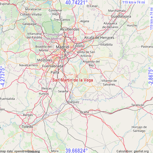
San Martín de la Vega GPS coordinates[2]
40° 12' 26.46" North, 3° 34' 14.268" West
| Map corner | latitude | longitude |
|---|---|---|
| Upper-left | 40.74221°, | -4.27375° |
| Center: | 40.20735°, | -3.57063° |
| Lower-right: | 39.66824°, | -2.8675° |
| Map W x H: | 119.4×119.4 km | = 74.2×74.2mi |
| max Lat: | 43.74134° ⇑67.1% North |
| San Martín de la Vega: | 40.20735° |
| min Lat: | ⇓32.9% South 27.64134° |
| min Long | San Martín de | max Long |
| -18.00367° | -3.57063° | 4.2899° |
| W 46.8%⇐ | ⇒53.2% E |
Elevation
Elevation of San Martín de la Vega is 518 m = 1699 ft, and this is 80 m = 262 ft below average elevation for this country.
| Max E: |
1682 m = 5518 ft | 60.7% |
| Avg. | 598 m = 1962 ft | |
| San Martín de la Vega | 518 m = 1699 ft | |
Min E: |
0 m = 0 ft | 39.3% |
See also: Spain elevation on elevation.city.
Geographical zone
San Martín de la Vega is located in North temperate zone (between Tropic of Cancer and the Arctic Circle). Distance of this Northern Tropic circle is 1864.7 km =1158.7 mi to South.| Distance of | km | miles | from San Martín de la Vega |
|---|---|---|---|
| North Pole | 5536.4 | 3440.2 | to North |
| Arctic Circle | 2930.5 | 1820.9 | to North |
| Tropic Cancer | 1864.7 | 1158.7 | to South |
| Equator | 4470.6 | 2777.9 | to South |


Nearby cities:
15 places around San Martín de la Vega: (largest is in red/bold)
• Arganda
15.4 km =9.6 mi,  47°
47°
• Chinchón
14.6 km =9.1 mi,  120°
120°
• Ciempozuelos
6.9 km =4.3 mi,  218°
218°
• Getafe
17.6 km =10.9 mi,  308°
308°
• Morata de Tajuña
11.9 km =7.4 mi,  79°
79°
• Parla
17 km =10.6 mi,  280°
280°
• Perales de Tajuña
18.9 km =11.7 mi, 81°
• Pinto
11.6 km =7.2 mi,  289°
289°
• Rivas-Vaciamadrid
14.1 km =8.8 mi,  21°
21°
• Seseña
15.7 km =9.8 mi, 223°
• Titulcia
8 km =5 mi,  178°
178°
• Torrejón de Velasco
17.6 km =10.9 mi,  262°
262°
• Valdemoro
9.4 km =5.8 mi, 258°
• Villa de Vallecas
17.9 km =11.1 mi,  351°
351°
• Villaconejos
14 km =8.7 mi,  147°
147°
Sources, notices
• [Note1] Compared only with cities in Spain existing in our database
• [Src1] Map data: © OpenStreetMap contributors (CC-BY-SA)
• [Src2] Other city data from geonames.org with taken over terms of usage.
• [Src3] Geographical zone / Annual Mean Temperature by Robert A. Rohde @ Wikipedia
