Villaconejos geodata
Villaconejos (Madrid) is a seat of a third-order administrative division; located in Spain in Europe/Madrid (GMT+2) time zone. With population of 3,010 people, there are 1716 cities with bigger population in this country. Compared to other cities in Spain, 68.8% of cities are located further ↑North; 51.9% of cities are located further →East and 52.1% of cities have higher elevation than Villaconejos. Note1


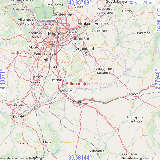
Villaconejos GPS coordinates[2]
40° 6' 5.004" North, 3° 28' 57.288" West
| Map corner | latitude | longitude |
|---|---|---|
| Upper-left | 40.63709°, | -4.18571° |
| Center: | 40.10139°, | -3.48258° |
| Lower-right: | 39.56144°, | -2.77946° |
| Map W x H: | 119.6×119.6 km | = 74.3×74.3mi |
| max Lat: | 43.74134° ⇑68.8% North |
| Villaconejos: | 40.10139° |
| min Lat: | ⇓31.2% South 27.64134° |
| min Long | Villaconejos | max Long |
| -18.00367° | -3.48258° | 4.2899° |
| W 48.1%⇐ | ⇒51.9% E |
Elevation
Elevation of Villaconejos is 635 m = 2083 ft, and this is 37 m = 121 ft above average elevation for this country.
| Max E: |
1682 m = 5518 ft | 52.1% |
| Villaconejos | 635 m 2083 ft | |
| Avg. | 598 m = 1962 ft | |
Min E: |
0 m = 0 ft | 47.9% |
See also: Spain elevation on elevation.city.
Geographical zone
Villaconejos is located in North temperate zone (between Tropic of Cancer and the Arctic Circle). Distance of this Northern Tropic circle is 1852.9 km =1151.3 mi to South.| Distance of | km | miles | from Villaconejos |
|---|---|---|---|
| North Pole | 5548.2 | 3447.5 | to North |
| Arctic Circle | 2942.3 | 1828.3 | to North |
| Tropic Cancer | 1852.9 | 1151.3 | to South |
| Equator | 4458.9 | 2770.6 | to South |


Nearby cities:
15 places around Villaconejos: (largest is in red/bold)
• Aranjuez
12.9 km =8 mi,  232°
232°
• Belmonte de Tajo
12.9 km =8 mi,  74°
74°
• Chinchón
6.7 km =4.2 mi,  49°
49°
• Ciempozuelos
13.4 km =8.3 mi,  298°
298°
• Colmenar de Oreja
8.3 km =5.2 mi,  85°
85°
• Morata de Tajuña
14.6 km =9.1 mi,  16°
16°
• Noblejas
13.9 km =8.6 mi,  164°
164°
• Ocaña
16 km =9.9 mi,  184°
184°
• Ontígola
13.2 km =8.2 mi,  215°
215°
• Perales de Tajuña
18.3 km =11.4 mi,  37°
37°
• San Martín de la Vega
14 km =8.7 mi,  327°
327°
• Seseña
18.3 km =11.4 mi,  271°
271°
• Titulcia
8.2 km =5.1 mi, 297°
• Villarejo de Salvanés
19.3 km =12 mi, 67°
• Villarrubia de Santiago
16.1 km =10 mi,  143°
143°
Sources, notices
• [Note1] Compared only with cities in Spain existing in our database
• [Src1] Map data: © OpenStreetMap contributors (CC-BY-SA)
• [Src2] Other city data from geonames.org with taken over terms of usage.
• [Src3] Geographical zone / Annual Mean Temperature by Robert A. Rohde @ Wikipedia
