Pinto geodata
Pinto (Madrid) is a seat of a third-order administrative division; located in Spain in Europe/Madrid (GMT+2) time zone. With population of 43,501 people, there are 201 cities with bigger population in this country. Compared to other cities in Spain, 66.5% of cities are located further ↑North; 55.4% of cities are located further →East and 54% of cities have higher elevation than Pinto. Note1


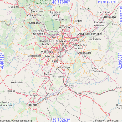
Pinto GPS coordinates[2]
40° 14' 29.292" North, 3° 41' 59.964" West
| Map corner | latitude | longitude |
|---|---|---|
| Upper-left | 40.77606°, | -4.40312° |
| Center: | 40.24147°, | -3.69999° |
| Lower-right: | 39.70263°, | -2.99687° |
| Map W x H: | 119.4×119.4 km | = 74.2×74.2mi |
| max Lat: | 43.74134° ⇑66.5% North |
| Pinto: | 40.24147° |
| min Lat: | ⇓33.5% South 27.64134° |
| min Long | Pinto | max Long |
| -18.00367° | -3.69999° | 4.2899° |
| W 44.6%⇐ | ⇒55.4% E |
Elevation
Elevation of Pinto is 612 m = 2008 ft, and this is 14 m = 46 ft above average elevation for this country.
| Max E: |
1682 m = 5518 ft | 54% |
| Pinto | 612 m 2008 ft | |
| Avg. | 598 m = 1962 ft | |
Min E: |
0 m = 0 ft | 46% |
See also: Pinto elevation on elevation.city.
Geographical zone
Pinto is located in North temperate zone (between Tropic of Cancer and the Arctic Circle). Distance of this Northern Tropic circle is 1868.5 km =1161 mi to South.| Distance of | km | miles | from Pinto |
|---|---|---|---|
| North Pole | 5532.6 | 3437.8 | to North |
| Arctic Circle | 2926.7 | 1818.6 | to North |
| Tropic Cancer | 1868.5 | 1161 | to South |
| Equator | 4474.4 | 2780.3 | to South |


Nearby cities:
15 places around Pinto: (largest is in red/bold)
• Casarrubuelos
13.6 km =8.5 mi,  235°
235°
• Ciempozuelos
11.3 km =7 mi,  143°
143°
• Cubas
12.9 km =8 mi, 243°
• Fuenlabrada
9.3 km =5.8 mi,  300°
300°
• Getafe
7.7 km =4.8 mi,  338°
338°
• Griñón
13.5 km =8.4 mi,  256°
256°
• Humanes de Madrid
11.1 km =6.9 mi,  275°
275°
• Leganés
10.9 km =6.8 mi,  330°
330°
• Moraleja de Enmedio
13.7 km =8.5 mi, 279°
• Parla
5.8 km =3.6 mi, 263°
• San Martín de la Vega
11.6 km =7.2 mi,  109°
109°
• Torrejón de Velasco
8.9 km =5.5 mi,  227°
227°
• Torrejón de la Calzada
9.5 km =5.9 mi, 240°
• Valdemoro
5.9 km =3.7 mi,  162°
162°
• Villaverde
12.1 km =7.5 mi,  359°
359°
Sources, notices
• [Note1] Compared only with cities in Spain existing in our database
• [Src1] Map data: © OpenStreetMap contributors (CC-BY-SA)
• [Src2] Other city data from geonames.org with taken over terms of usage.
• [Src3] Geographical zone / Annual Mean Temperature by Robert A. Rohde @ Wikipedia
