Forcarei geodata
Forcarei (Galicia) is a seat of a third-order administrative division; located in Spain in Europe/Madrid (GMT+2) time zone. In our database, there are 6762 cities with bigger population. Compared to other cities in Spain, 89.4% of cities are located further ↓South; 97.1% of cities are located further →East and 55.1% of cities have higher elevation than Forcarei. Note1


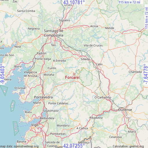
Forcarei GPS coordinates[2]
42° 35' 32.388" North, 8° 21' 3.24" West
| Map corner | latitude | longitude |
|---|---|---|
| Upper-left | 43.10781°, | -9.05403° |
| Center: | 42.59233°, | -8.3509° |
| Lower-right: | 42.07255°, | -7.64778° |
| Map W x H: | 115.1×115.1 km | = 71.5×71.5mi |
| max Lat: | 43.74134° ⇑10.6% North |
| Forcarei: | 42.59233° |
| min Lat: | ⇓89.4% South 27.64134° |
| min Long | Forcarei | max Long |
| -18.00367° | -8.3509° | 4.2899° |
| W 2.9%⇐ | ⇒97.1% E |
Elevation
Elevation of Forcarei is 594 m = 1949 ft, and this is 4 m = 13 ft below average elevation for this country.
| Max E: |
1682 m = 5518 ft | 55.1% |
| Avg. | 598 m = 1962 ft | |
| Forcarei | 594 m = 1949 ft | |
Min E: |
0 m = 0 ft | 44.9% |
See also: Spain elevation on elevation.city.
Geographical zone
Forcarei is located in North temperate zone (between Tropic of Cancer and the Arctic Circle). Distance of this Northern Tropic circle is 2129.9 km =1323.5 mi to South.| Distance of | km | miles | from Forcarei |
|---|---|---|---|
| North Pole | 5271.2 | 3275.4 | to North |
| Arctic Circle | 2665.4 | 1656.2 | to North |
| Tropic Cancer | 2129.9 | 1323.5 | to South |
| Equator | 4735.8 | 2942.7 | to South |


Nearby cities:
15 places around Forcarei: (largest is in red/bold)
• A Estrada
15.6 km =9.7 mi,  313°
313°
• Avión
24.7 km =15.3 mi,  160°
160°
• Barro
22.6 km =14 mi,  259°
259°
• Boborás
24.5 km =15.2 mi,  136°
136°
• Caldas de Reis
23.9 km =14.9 mi,  273°
273°
• Cuntis
17.9 km =11.1 mi,  284°
284°
• Lalín
20.9 km =13 mi,  68°
68°
• Lama
22.4 km =13.9 mi,  197°
197°
• Moraña
19.6 km =12.2 mi, 256°
• Ponte Caldelas
25.8 km =16 mi,  208°
208°
• Portas
25 km =15.5 mi, 268°
• Ribeira
18.7 km =11.6 mi,  336°
336°
• Silleda
14.3 km =8.9 mi,  36°
36°
• Teo
21.4 km =13.3 mi,  325°
325°
• Vedra
23.1 km =14.4 mi, 333°
Sources, notices
• [Note1] Compared only with cities in Spain existing in our database
• [Src1] Map data: © OpenStreetMap contributors (CC-BY-SA)
• [Src2] Other city data from geonames.org with taken over terms of usage.
• [Src3] Geographical zone / Annual Mean Temperature by Robert A. Rohde @ Wikipedia
