Silleda geodata
Silleda (Galicia) is a seat of a third-order administrative division; located in Spain in Europe/Madrid (GMT+2) time zone. With population of 9,018 people, there are 890 cities with bigger population in this country. Compared to other cities in Spain, 91.4% of cities are located further ↓South; 96.9% of cities are located further →East and 62.4% of cities have higher elevation than Silleda. Note1


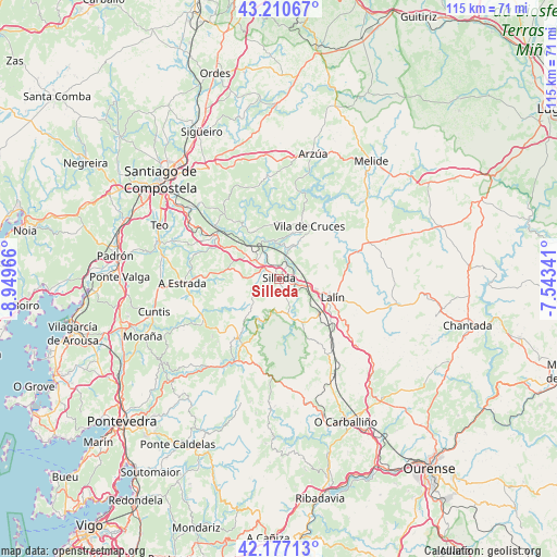
Silleda GPS coordinates[2]
42° 41' 45.78" North, 8° 14' 47.508" West
| Map corner | latitude | longitude |
|---|---|---|
| Upper-left | 43.21067°, | -8.94966° |
| Center: | 42.69605°, | -8.24653° |
| Lower-right: | 42.17713°, | -7.54341° |
| Map W x H: | 114.9×114.9 km | = 71.4×71.4mi |
| max Lat: | 43.74134° ⇑8.6% North |
| Silleda: | 42.69605° |
| min Lat: | ⇓91.4% South 27.64134° |
| min Long | Silleda | max Long |
| -18.00367° | -8.24653° | 4.2899° |
| W 3.1%⇐ | ⇒96.9% E |
Elevation
Elevation of Silleda is 494 m = 1621 ft, and this is 104 m = 341 ft below average elevation for this country.
| Max E: |
1682 m = 5518 ft | 62.4% |
| Avg. | 598 m = 1962 ft | |
| Silleda | 494 m = 1621 ft | |
Min E: |
0 m = 0 ft | 37.6% |
See also: Spain elevation on elevation.city.
Geographical zone
Silleda is located in North temperate zone (between Tropic of Cancer and the Arctic Circle). Distance of this Northern Tropic circle is 2141.4 km =1330.6 mi to South.| Distance of | km | miles | from Silleda |
|---|---|---|---|
| North Pole | 5259.7 | 3268.2 | to North |
| Arctic Circle | 2653.8 | 1649 | to North |
| Tropic Cancer | 2141.4 | 1330.6 | to South |
| Equator | 4747.4 | 2949.9 | to South |


Nearby cities:
15 places around Silleda: (largest is in red/bold)
• A Estrada
19.8 km =12.3 mi,  267°
267°
• Arzúa
27.5 km =17.1 mi,  16°
16°
• Boborás
30.4 km =18.9 mi,  164°
164°
• Cuntis
26.7 km =16.6 mi,  255°
255°
• Dozón
22.6 km =14 mi,  123°
123°
• Forcarei
14.3 km =8.9 mi,  216°
216°
• Lalín
11.6 km =7.2 mi,  109°
109°
• Melide
30.7 km =19.1 mi,  37°
37°
• Piñor
29.5 km =18.3 mi,  137°
137°
• Ribeira
17.1 km =10.6 mi,  289°
289°
• Rodeiro
24.3 km =15.1 mi,  101°
101°
• Santiso
25.2 km =15.7 mi, 38°
• Teo
21.6 km =13.4 mi, 286°
• Touro
19.8 km =12.3 mi,  345°
345°
• Vedra
20.9 km =13 mi,  295°
295°
Sources, notices
• [Note1] Compared only with cities in Spain existing in our database
• [Src1] Map data: © OpenStreetMap contributors (CC-BY-SA)
• [Src2] Other city data from geonames.org with taken over terms of usage.
• [Src3] Geographical zone / Annual Mean Temperature by Robert A. Rohde @ Wikipedia
