Sober geodata
Sober (Galicia) is a seat of a third-order administrative division; located in Spain in Europe/Madrid (GMT+2) time zone. With population of 2,983 people, there are 1729 cities with bigger population in this country. Compared to other cities in Spain, 86.3% of cities are located further ↓South; 95.5% of cities are located further →East and 69.2% of cities have higher elevation than Sober. Note1


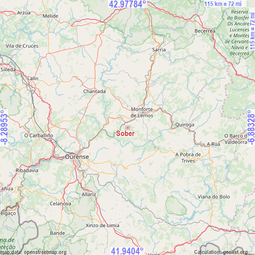
Sober GPS coordinates[2]
42° 27' 40.572" North, 7° 35' 11.04" West
| Map corner | latitude | longitude |
|---|---|---|
| Upper-left | 42.97784°, | -8.28953° |
| Center: | 42.46127°, | -7.5864° |
| Lower-right: | 41.9404°, | -6.88328° |
| Map W x H: | 115.4×115.4 km | = 71.7×71.7mi |
| max Lat: | 43.74134° ⇑13.7% North |
| Sober: | 42.46127° |
| min Lat: | ⇓86.3% South 27.64134° |
| min Long | Sober | max Long |
| -18.00367° | -7.5864° | 4.2899° |
| W 4.5%⇐ | ⇒95.5% E |
Elevation
Elevation of Sober is 396 m = 1299 ft, and this is 202 m = 663 ft below average elevation for this country.
| Max E: |
1682 m = 5518 ft | 69.2% |
| Avg. | 598 m = 1962 ft | |
| Sober | 396 m = 1299 ft | |
Min E: |
0 m = 0 ft | 30.8% |
See also: Spain elevation on elevation.city.
Geographical zone
Sober is located in North temperate zone (between Tropic of Cancer and the Arctic Circle). Distance of this Northern Tropic circle is 2115.3 km =1314.4 mi to South.| Distance of | km | miles | from Sober |
|---|---|---|---|
| North Pole | 5285.8 | 3284.4 | to North |
| Arctic Circle | 2679.9 | 1665.2 | to North |
| Tropic Cancer | 2115.3 | 1314.4 | to South |
| Equator | 4721.3 | 2933.7 | to South |


Nearby cities:
15 places around Sober: (largest is in red/bold)
• A Pobra do Brollon
19.1 km =11.9 mi,  56°
56°
• Bóveda
20.3 km =12.6 mi,  26°
26°
• Carballedo
21 km =13 mi,  288°
288°
• Castro Caldelas
16.4 km =10.2 mi,  126°
126°
• Chantada
22.3 km =13.9 mi,  317°
317°
• Coles
21.4 km =13.3 mi,  251°
251°
• Esgos
17.6 km =10.9 mi,  211°
211°
• Lobios
7.5 km =4.7 mi,  143°
143°
• Luintra
12.9 km =8 mi,  243°
243°
• Maceda
21.9 km =13.6 mi,  193°
193°
• Monforte de Lemos
8.9 km =5.5 mi,  41°
41°
• Montederramo
21.8 km =13.5 mi,  161°
161°
• Nogueira de Ramuín
14.3 km =8.9 mi, 249°
• Pantón
6.3 km =3.9 mi,  349°
349°
• Pereiro de Aguiar
21.8 km =13.5 mi,  233°
233°
Sources, notices
• [Note1] Compared only with cities in Spain existing in our database
• [Src1] Map data: © OpenStreetMap contributors (CC-BY-SA)
• [Src2] Other city data from geonames.org with taken over terms of usage.
• [Src3] Geographical zone / Annual Mean Temperature by Robert A. Rohde @ Wikipedia
