Reocín geodata
Reocín (Cantabria) is a seat of a third-order administrative division; located in Spain in Europe/Madrid (GMT+2) time zone. With population of 7,230 people, there are 1011 cities with bigger population in this country. Compared to other cities in Spain, 98.1% of cities are located further ↓South; 61.1% of cities are located further →East and 87.3% of cities have higher elevation than Reocín. Note1


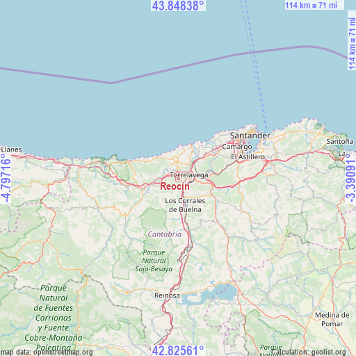
Reocín GPS coordinates[2]
43° 20' 20.94" North, 4° 5' 38.508" West
| Map corner | latitude | longitude |
|---|---|---|
| Upper-left | 43.84838°, | -4.79716° |
| Center: | 43.33915°, | -4.09403° |
| Lower-right: | 42.82561°, | -3.39091° |
| Map W x H: | 113.7×113.7 km | = 70.6×70.6mi |
| max Lat: | 43.74134° ⇑1.9% North |
| Reocín: | 43.33915° |
| min Lat: | ⇓98.1% South 27.64134° |
| min Long | Reocín | max Long |
| -18.00367° | -4.09403° | 4.2899° |
| W 38.9%⇐ | ⇒61.1% E |
Elevation
Elevation of Reocín is 105 m = 344 ft, and this is 493 m = 1617 ft below average elevation for this country.
| Max E: |
1682 m = 5518 ft | 87.3% |
| Avg. | 598 m = 1962 ft | |
| Reocín | 105 m = 344 ft | |
Min E: |
0 m = 0 ft | 12.7% |
See also: Spain elevation on elevation.city.
Geographical zone
Reocín is located in North temperate zone (between Tropic of Cancer and the Arctic Circle). Distance of this Northern Tropic circle is 2212.9 km =1375 mi to South.| Distance of | km | miles | from Reocín |
|---|---|---|---|
| North Pole | 5188.2 | 3223.8 | to North |
| Arctic Circle | 2582.3 | 1604.6 | to North |
| Tropic Cancer | 2212.9 | 1375 | to South |
| Equator | 4818.9 | 2994.3 | to South |


Nearby cities:
15 places around Reocín: (largest is in red/bold)
• Arenas de Iguña
17.8 km =11.1 mi,  167°
167°
• Barrio de la Iglesia
13.5 km =8.4 mi,  290°
290°
• Cabezón de la Sal
12 km =7.5 mi,  253°
253°
• Cartes
2.5 km =1.6 mi,  125°
125°
• Comillas
16.8 km =10.4 mi, 288°
• Los Corrales de Buelna
8.6 km =5.3 mi, 168°
• Luzmela
10.4 km =6.5 mi,  243°
243°
• Miengo
12.6 km =7.8 mi,  37°
37°
• Polanco
8.1 km =5 mi,  50°
50°
• Puente Viesgo
11.2 km =7 mi,  114°
114°
• Ruente
16.7 km =10.4 mi, 237°
• Santillana
5.7 km =3.5 mi,  348°
348°
• Santiurde de Toranzo
16.8 km =10.4 mi, 131°
• Suances
11.3 km =7 mi,  21°
21°
• Torrelavega
3.9 km =2.4 mi,  72°
72°
Sources, notices
• [Note1] Compared only with cities in Spain existing in our database
• [Src1] Map data: © OpenStreetMap contributors (CC-BY-SA)
• [Src2] Other city data from geonames.org with taken over terms of usage.
• [Src3] Geographical zone / Annual Mean Temperature by Robert A. Rohde @ Wikipedia
