Torrelavega geodata
Torrelavega (Cantabria) is a populated place; located in Spain in Europe/Madrid (GMT+2) time zone. With population of 55,297 people, there are 169 cities with bigger population in this country. Compared to other cities in Spain, 98.2% of cities are located further ↓South; 60.5% of cities are located further →East and 94% of cities have higher elevation than Torrelavega. Note1


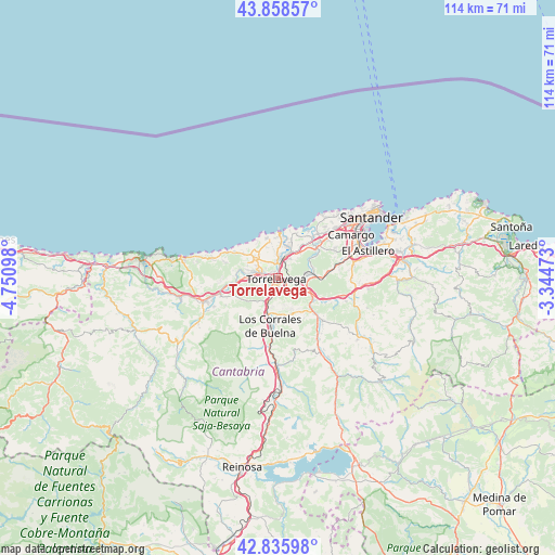
Torrelavega GPS coordinates[2]
43° 20' 57.948" North, 4° 2' 52.26" West
| Map corner | latitude | longitude |
|---|---|---|
| Upper-left | 43.85857°, | -4.75098° |
| Center: | 43.34943°, | -4.04785° |
| Lower-right: | 42.83598°, | -3.34473° |
| Map W x H: | 113.7×113.7 km | = 70.6×70.6mi |
| max Lat: | 43.74134° ⇑1.8% North |
| Torrelavega: | 43.34943° |
| min Lat: | ⇓98.2% South 27.64134° |
| min Long | Torrelavega | max Long |
| -18.00367° | -4.04785° | 4.2899° |
| W 39.5%⇐ | ⇒60.5% E |
Elevation
Elevation of Torrelavega is 31 m = 102 ft, and this is 567 m = 1860 ft below average elevation for this country.
| Max E: |
1682 m = 5518 ft | 94% |
| Avg. | 598 m = 1962 ft | |
| Torrelavega | 31 m = 102 ft | |
Min E: |
0 m = 0 ft | 6% |
See also: Torrelavega elevation on elevation.city.
Geographical zone
Torrelavega is located in North temperate zone (between Tropic of Cancer and the Arctic Circle). Distance of this Northern Tropic circle is 2214.1 km =1375.8 mi to South.| Distance of | km | miles | from Torrelavega |
|---|---|---|---|
| North Pole | 5187.1 | 3223.1 | to North |
| Arctic Circle | 2581.2 | 1603.9 | to North |
| Tropic Cancer | 2214.1 | 1375.8 | to South |
| Equator | 4820 | 2995 | to South |


Nearby cities:
15 places around Torrelavega: (largest is in red/bold)
• Cabezón de la Sal
15.9 km =9.9 mi,  253°
253°
• Camargo
14.7 km =9.1 mi,  63°
63°
• Cartes
3.1 km =1.9 mi,  213°
213°
• Los Corrales de Buelna
9.8 km =6.1 mi,  191°
191°
• Luzmela
14.3 km =8.9 mi, 245°
• Miengo
9.7 km =6 mi,  24°
24°
• Polanco
4.7 km =2.9 mi,  32°
32°
• Puente Viesgo
8.6 km =5.3 mi,  131°
131°
• Reocín
3.9 km =2.4 mi, 252°
• Santa Cruz de Bezana
15.7 km =9.8 mi,  48°
48°
• Santillana
6.6 km =4.1 mi,  311°
311°
• Santiurde de Toranzo
15.2 km =9.4 mi,  144°
144°
• Suances
9.3 km =5.8 mi,  2°
2°
• Villafufre
15.6 km =9.7 mi, 126°
• Villanueva de Villaescusa
15.1 km =9.4 mi,  82°
82°
Sources, notices
• [Note1] Compared only with cities in Spain existing in our database
• [Src1] Map data: © OpenStreetMap contributors (CC-BY-SA)
• [Src2] Other city data from geonames.org with taken over terms of usage.
• [Src3] Geographical zone / Annual Mean Temperature by Robert A. Rohde @ Wikipedia
