Torreblanca geodata
Torreblanca (Valencia) is a seat of a third-order administrative division; located in Spain in Europe/Madrid (GMT+2) time zone. With population of 5,626 people, there are 1189 cities with bigger population in this country. Compared to other cities in Spain, 66.9% of cities are located further ↑North; 88% of cities are located further ←West and 94.1% of cities have higher elevation than Torreblanca. Note1


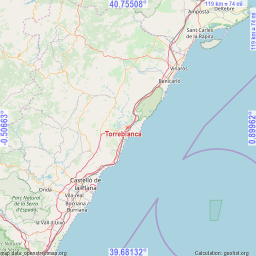
Torreblanca GPS coordinates[2]
40° 13' 13.188" North, 0° 11' 47.4" East
| Map corner | latitude | longitude |
|---|---|---|
| Upper-left | 40.75508°, | -0.50663° |
| Center: | 40.22033°, | 0.1965° |
| Lower-right: | 39.68132°, | 0.89962° |
| Map W x H: | 119.4×119.4 km | = 74.2×74.2mi |
| max Lat: | 43.74134° ⇑66.9% North |
| Torreblanca: | 40.22033° |
| min Lat: | ⇓33.1% South 27.64134° |
| min Long | Torreblanca | max Long |
| -18.00367° | 0.1965° | 4.2899° |
| W 88%⇐ | ⇒12% E |
Elevation
Elevation of Torreblanca is 30 m = 98 ft, and this is 568 m = 1864 ft below average elevation for this country.
| Max E: |
1682 m = 5518 ft | 94.1% |
| Avg. | 598 m = 1962 ft | |
| Torreblanca | 30 m = 98 ft | |
Min E: |
0 m = 0 ft | 5.9% |
See also: Spain elevation on elevation.city.
Geographical zone
Torreblanca is located in North temperate zone (between Tropic of Cancer and the Arctic Circle). Distance of this Northern Tropic circle is 1866.2 km =1159.6 mi to South.| Distance of | km | miles | from Torreblanca |
|---|---|---|---|
| North Pole | 5535 | 3439.3 | to North |
| Arctic Circle | 2929.1 | 1820.1 | to North |
| Tropic Cancer | 1866.2 | 1159.6 | to South |
| Equator | 4472.1 | 2778.8 | to South |


Nearby cities:
15 places around Torreblanca: (largest is in red/bold)
• Albocàsser
20 km =12.4 mi,  316°
316°
• Alcalà de Xivert
9.4 km =5.8 mi,  19°
19°
• Alcocéber
8.2 km =5.1 mi,  65°
65°
• Benicàssim
21.9 km =13.6 mi,  210°
210°
• Benlloch
14.4 km =8.9 mi,  265°
265°
• Cabanes
14.9 km =9.3 mi,  241°
241°
• Cuevas de Vinromá
11.8 km =7.3 mi,  327°
327°
• Oropesa del Mar
15.1 km =9.4 mi,  198°
198°
• Peníscola
23.5 km =14.6 mi,  49°
49°
• Puebla Tornesa
21.3 km =13.2 mi,  232°
232°
• Salsadella
22 km =13.7 mi,  355°
355°
• Santa Magdalena de Pulpis
17.6 km =10.9 mi,  30°
30°
• Sarratella
17.4 km =10.8 mi,  306°
306°
• Sierra-Engarcerán
19.1 km =11.9 mi,  286°
286°
• Villafamés
23.9 km =14.9 mi, 241°
Sources, notices
• [Note1] Compared only with cities in Spain existing in our database
• [Src1] Map data: © OpenStreetMap contributors (CC-BY-SA)
• [Src2] Other city data from geonames.org with taken over terms of usage.
• [Src3] Geographical zone / Annual Mean Temperature by Robert A. Rohde @ Wikipedia
