Alcocéber geodata
Alcocéber (Valencia) is a populated place; located in Spain in Europe/Madrid (GMT+2) time zone. With population of 5,000 people, there are 1308 cities with bigger population in this country. Compared to other cities in Spain, 66.4% of cities are located further ↑North; 88.3% of cities are located further ←West and 97.3% of cities have higher elevation than Alcocéber. Note1
Administrative division(s):
- Level 1: Valencia
- Level 2: Província de Castelló
- Level 3: Alcalà de Xivert


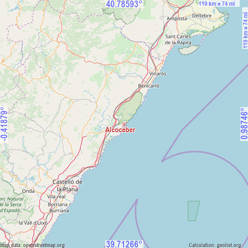
Alcocéber GPS coordinates[2]
40° 15' 5.112" North, 0° 17' 3.588" East
| Map corner | latitude | longitude |
|---|---|---|
| Upper-left | 40.78593°, | -0.41879° |
| Center: | 40.25142°, | 0.28433° |
| Lower-right: | 39.71266°, | 0.98746° |
| Map W x H: | 119.3×119.3 km | = 74.1×74.1mi |
| max Lat: | 43.74134° ⇑66.4% North |
| Alcocéber: | 40.25142° |
| min Lat: | ⇓33.6% South 27.64134° |
| min Long | Alcocéber | max Long |
| -18.00367° | 0.28433° | 4.2899° |
| W 88.3%⇐ | ⇒11.7% E |
Elevation
Elevation of Alcocéber is 14 m = 46 ft, and this is 584 m = 1916 ft below average elevation for this country.
| Max E: |
1682 m = 5518 ft | 97.3% |
| Avg. | 598 m = 1962 ft | |
| Alcocéber | 14 m = 46 ft | |
Min E: |
0 m = 0 ft | 2.7% |
See also: Spain elevation on elevation.city.
Geographical zone
Alcocéber is located in North temperate zone (between Tropic of Cancer and the Arctic Circle). Distance of this Northern Tropic circle is 1869.6 km =1161.7 mi to South.| Distance of | km | miles | from Alcocéber |
|---|---|---|---|
| North Pole | 5531.5 | 3437.1 | to North |
| Arctic Circle | 2925.6 | 1817.9 | to North |
| Tropic Cancer | 1869.6 | 1161.7 | to South |
| Equator | 4475.5 | 2780.9 | to South |


Nearby cities:
15 places around Alcocéber: (largest is in red/bold)
• Albocàsser
23.9 km =14.9 mi,  297°
297°
• Alcalà de Xivert
6.9 km =4.3 mi,  321°
321°
• Benicarló
22 km =13.7 mi,  33°
33°
• Benlloch
22.3 km =13.9 mi,  258°
258°
• Cabanes
23.1 km =14.4 mi,  242°
242°
• Cervera del Maestre
22.5 km =14 mi,  358°
358°
• Cuevas de Vinromá
15.3 km =9.5 mi, 295°
• Càlig
24.2 km =15 mi,  14°
14°
• Oropesa del Mar
21.6 km =13.4 mi,  214°
214°
• Peníscola
15.7 km =9.8 mi,  41°
41°
• Salsadella
20.7 km =12.9 mi,  333°
333°
• Santa Magdalena de Pulpis
11.8 km =7.3 mi, 7°
• Sarratella
22.5 km =14 mi,  287°
287°
• Sierra-Engarcerán
25.8 km =16 mi,  274°
274°
• Torreblanca
8.2 km =5.1 mi,  245°
245°
Sources, notices
• [Note1] Compared only with cities in Spain existing in our database
• [Src1] Map data: © OpenStreetMap contributors (CC-BY-SA)
• [Src2] Other city data from geonames.org with taken over terms of usage.
• [Src3] Geographical zone / Annual Mean Temperature by Robert A. Rohde @ Wikipedia
