Manchones geodata
Manchones (Aragon) is a seat of a third-order administrative division; located in Spain in Europe/Madrid (GMT+2) time zone. With population of 146 people, there are 5457 cities with bigger population in this country. Compared to other cities in Spain, 52.1% of cities are located further ↓South; 73.3% of cities are located further ←West and 57.4% of cities have lower elevation than Manchones. Note1


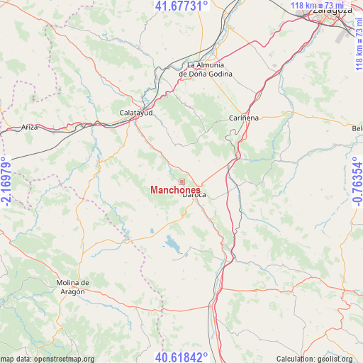
Manchones GPS coordinates[2]
41° 9' 0" North, 1° 28' 0.012" West
| Map corner | latitude | longitude |
|---|---|---|
| Upper-left | 41.67731°, | -2.16979° |
| Center: | 41.15°, | -1.46667° |
| Lower-right: | 40.61842°, | -0.76354° |
| Map W x H: | 117.7×117.7 km | = 73.1×73.1mi |
| max Lat: | 43.74134° ⇑47.9% North |
| Manchones: | 41.15° |
| min Lat: | ⇓52.1% South 27.64134° |
| min Long | Manchones | max Long |
| -18.00367° | -1.46667° | 4.2899° |
| W 73.3%⇐ | ⇒26.7% E |
Elevation
Elevation of Manchones is 726 m = 2382 ft, and this is 128 m = 420 ft above average elevation for this country.
| Max E: |
1682 m = 5518 ft | 42.6% |
| Manchones | 726 m 2382 ft | |
| Avg. | 598 m = 1962 ft | |
Min E: |
0 m = 0 ft | 57.4% |
See also: Spain elevation on elevation.city.
Geographical zone
Manchones is located in North temperate zone (between Tropic of Cancer and the Arctic Circle). Distance of this Northern Tropic circle is 1969.5 km =1223.8 mi to South.| Distance of | km | miles | from Manchones |
|---|---|---|---|
| North Pole | 5431.6 | 3375 | to North |
| Arctic Circle | 2825.7 | 1755.8 | to North |
| Tropic Cancer | 1969.5 | 1223.8 | to South |
| Equator | 4575.5 | 2843.1 | to South |


Nearby cities:
15 places around Manchones: (largest is in red/bold)
• Atea
7.5 km =4.7 mi,  279°
279°
• Balconchán
7 km =4.3 mi,  175°
175°
• Daroca
5.8 km =3.6 mi,  132°
132°
• Fuentes de Jiloca
10.5 km =6.5 mi,  326°
326°
• Langa del Castillo
8.9 km =5.5 mi,  39°
39°
• Montón
7.5 km =4.7 mi, 327°
• Murero
1.7 km =1.1 mi,  308°
308°
• Nombrevilla
10.2 km =6.3 mi,  117°
117°
• Orcajo
4.9 km =3 mi,  202°
202°
• Retascón
7 km =4.3 mi,  95°
95°
• San Martín del Río
11.4 km =7.1 mi,  144°
144°
• Val de San Martín
10.3 km =6.4 mi,  171°
171°
• Valdehorna
9.3 km =5.8 mi,  157°
157°
• Villafeliche
6.2 km =3.9 mi,  324°
324°
• Villanueva de Jiloca
10.4 km =6.5 mi, 141°
Sources, notices
• [Note1] Compared only with cities in Spain existing in our database
• [Src1] Map data: © OpenStreetMap contributors (CC-BY-SA)
• [Src2] Other city data from geonames.org with taken over terms of usage.
• [Src3] Geographical zone / Annual Mean Temperature by Robert A. Rohde @ Wikipedia
