Atea geodata
Atea (Aragon) is a seat of a third-order administrative division; located in Spain in Europe/Madrid (GMT+2) time zone. With population of 171 people, there are 5259 cities with bigger population in this country. Compared to other cities in Spain, 52.3% of cities are located further ↓South; 72.4% of cities are located further ←West and 73.5% of cities have lower elevation than Atea. Note1


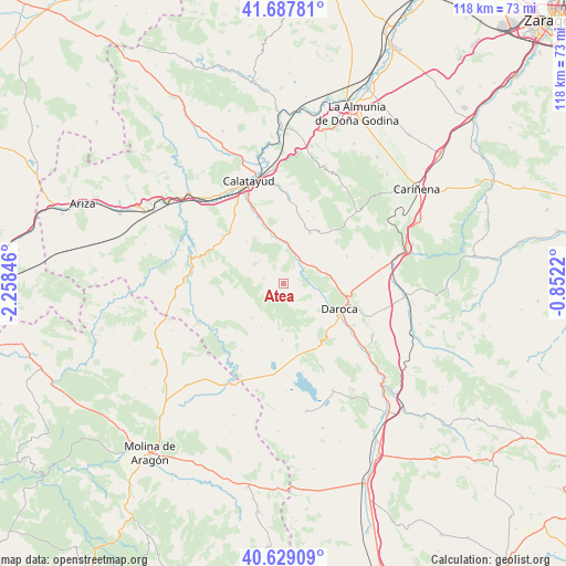
Atea GPS coordinates[2]
41° 9' 38.124" North, 1° 33' 19.188" West
| Map corner | latitude | longitude |
|---|---|---|
| Upper-left | 41.68781°, | -2.25846° |
| Center: | 41.16059°, | -1.55533° |
| Lower-right: | 40.62909°, | -0.8522° |
| Map W x H: | 117.7×117.7 km | = 73.1×73.1mi |
| max Lat: | 43.74134° ⇑47.7% North |
| Atea: | 41.16059° |
| min Lat: | ⇓52.3% South 27.64134° |
| min Long | Atea | max Long |
| -18.00367° | -1.55533° | 4.2899° |
| W 72.4%⇐ | ⇒27.6% E |
Elevation
Elevation of Atea is 839 m = 2753 ft, and this is 241 m = 791 ft above average elevation for this country.
| Max E: |
1682 m = 5518 ft | 26.5% |
| Atea | 839 m 2753 ft | |
| Avg. | 598 m = 1962 ft | |
Min E: |
0 m = 0 ft | 73.5% |
See also: Spain elevation on elevation.city.
Geographical zone
Atea is located in North temperate zone (between Tropic of Cancer and the Arctic Circle). Distance of this Northern Tropic circle is 1970.7 km =1224.5 mi to South.| Distance of | km | miles | from Atea |
|---|---|---|---|
| North Pole | 5430.4 | 3374.3 | to North |
| Arctic Circle | 2824.5 | 1755.1 | to North |
| Tropic Cancer | 1970.7 | 1224.5 | to South |
| Equator | 4576.6 | 2843.8 | to South |


Nearby cities:
15 places around Atea: (largest is in red/bold)
• Abanto
12.2 km =7.6 mi,  257°
257°
• Acered
4.2 km =2.6 mi,  285°
285°
• Alarba
6.9 km =4.3 mi,  315°
315°
• Balconchán
11.4 km =7.1 mi,  135°
135°
• Castejón de Alarba
7.2 km =4.5 mi, 290°
• Cubel
9.9 km =6.2 mi,  223°
223°
• Fuentes de Jiloca
7.7 km =4.8 mi,  11°
11°
• Manchones
7.5 km =4.7 mi,  99°
99°
• Montón
6.1 km =3.8 mi,  33°
33°
• Morata de Jiloca
10.1 km =6.3 mi,  344°
344°
• Murero
6.1 km =3.8 mi,  90°
90°
• Olvés
11.6 km =7.2 mi, 319°
• Orcajo
7.9 km =4.9 mi, 135°
• Used
11.7 km =7.3 mi,  181°
181°
• Villafeliche
5.4 km =3.4 mi,  44°
44°
Sources, notices
• [Note1] Compared only with cities in Spain existing in our database
• [Src1] Map data: © OpenStreetMap contributors (CC-BY-SA)
• [Src2] Other city data from geonames.org with taken over terms of usage.
• [Src3] Geographical zone / Annual Mean Temperature by Robert A. Rohde @ Wikipedia
