Murero geodata
Murero (Aragon) is a seat of a third-order administrative division; located in Spain in Europe/Madrid (GMT+2) time zone. With population of 139 people, there are 5510 cities with bigger population in this country. Compared to other cities in Spain, 52.3% of cities are located further ↓South; 73.1% of cities are located further ←West and 56.8% of cities have lower elevation than Murero. Note1


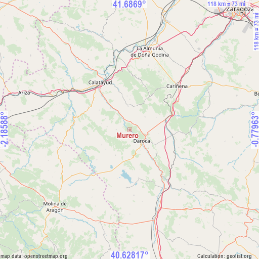
Murero GPS coordinates[2]
41° 9' 34.812" North, 1° 28' 57.9" West
| Map corner | latitude | longitude |
|---|---|---|
| Upper-left | 41.6869°, | -2.18588° |
| Center: | 41.15967°, | -1.48275° |
| Lower-right: | 40.62817°, | -0.77963° |
| Map W x H: | 117.7×117.7 km | = 73.1×73.1mi |
| max Lat: | 43.74134° ⇑47.7% North |
| Murero: | 41.15967° |
| min Lat: | ⇓52.3% South 27.64134° |
| min Long | Murero | max Long |
| -18.00367° | -1.48275° | 4.2899° |
| W 73.1%⇐ | ⇒26.9% E |
Elevation
Elevation of Murero is 722 m = 2369 ft, and this is 124 m = 407 ft above average elevation for this country.
| Max E: |
1682 m = 5518 ft | 43.2% |
| Murero | 722 m 2369 ft | |
| Avg. | 598 m = 1962 ft | |
Min E: |
0 m = 0 ft | 56.8% |
See also: Spain elevation on elevation.city.
Geographical zone
Murero is located in North temperate zone (between Tropic of Cancer and the Arctic Circle). Distance of this Northern Tropic circle is 1970.6 km =1224.5 mi to South.| Distance of | km | miles | from Murero |
|---|---|---|---|
| North Pole | 5430.5 | 3374.4 | to North |
| Arctic Circle | 2824.6 | 1755.1 | to North |
| Tropic Cancer | 1970.6 | 1224.5 | to South |
| Equator | 4576.5 | 2843.7 | to South |


Nearby cities:
15 places around Murero: (largest is in red/bold)
• Acered
10.2 km =6.3 mi,  276°
276°
• Alarba
12 km =7.5 mi,  294°
294°
• Atea
6.1 km =3.8 mi,  270°
270°
• Balconchán
8.3 km =5.2 mi,  166°
166°
• Daroca
7.6 km =4.7 mi,  131°
131°
• Fuentes de Jiloca
8.9 km =5.5 mi,  329°
329°
• Langa del Castillo
9.1 km =5.7 mi,  50°
50°
• Manchones
1.7 km =1.1 mi, 128°
• Montón
5.9 km =3.7 mi, 332°
• Nombrevilla
11.9 km =7.4 mi,  119°
119°
• Orcajo
5.6 km =3.5 mi,  185°
185°
• Retascón
8.5 km =5.3 mi,  102°
102°
• Val de San Martín
11.7 km =7.3 mi, 166°
• Valdehorna
10.9 km =6.8 mi,  152°
152°
• Villafeliche
4.5 km =2.8 mi, 330°
Sources, notices
• [Note1] Compared only with cities in Spain existing in our database
• [Src1] Map data: © OpenStreetMap contributors (CC-BY-SA)
• [Src2] Other city data from geonames.org with taken over terms of usage.
• [Src3] Geographical zone / Annual Mean Temperature by Robert A. Rohde @ Wikipedia
