Caspe geodata
Caspe (Aragon) is a seat of a third-order administrative division; located in Spain in Europe/Madrid (GMT+2) time zone. With population of 8,054 people, there are 933 cities with bigger population in this country. Compared to other cities in Spain, 54.1% of cities are located further ↓South; 86.8% of cities are located further ←West and 82.8% of cities have higher elevation than Caspe. Note1


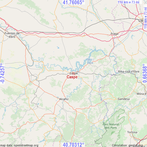
Caspe GPS coordinates[2]
41° 14' 2.472" North, 0° 2' 22.02" West
| Map corner | latitude | longitude |
|---|---|---|
| Upper-left | 41.76065°, | -0.74257° |
| Center: | 41.23402°, | -0.03945° |
| Lower-right: | 40.70312°, | 0.66368° |
| Map W x H: | 117.6×117.6 km | = 73.1×73.1mi |
| max Lat: | 43.74134° ⇑45.9% North |
| Caspe: | 41.23402° |
| min Lat: | ⇓54.1% South 27.64134° |
| min Long | Caspe | max Long |
| -18.00367° | -0.03945° | 4.2899° |
| W 86.8%⇐ | ⇒13.2% E |
Elevation
Elevation of Caspe is 171 m = 561 ft, and this is 427 m = 1401 ft below average elevation for this country.
| Max E: |
1682 m = 5518 ft | 82.8% |
| Avg. | 598 m = 1962 ft | |
| Caspe | 171 m = 561 ft | |
Min E: |
0 m = 0 ft | 17.2% |
See also: Spain elevation on elevation.city.
Geographical zone
Caspe is located in North temperate zone (between Tropic of Cancer and the Arctic Circle). Distance of this Northern Tropic circle is 1978.9 km =1229.6 mi to South.| Distance of | km | miles | from Caspe |
|---|---|---|---|
| North Pole | 5422.3 | 3369.3 | to North |
| Arctic Circle | 2816.4 | 1750 | to North |
| Tropic Cancer | 1978.9 | 1229.6 | to South |
| Equator | 4584.8 | 2848.9 | to South |


Nearby cities:
15 places around Caspe: (largest is in red/bold)
• Alborge
28.7 km =17.8 mi,  292°
292°
• Alcañiz
21.9 km =13.6 mi,  201°
201°
• Castelnou
27.2 km =16.9 mi,  268°
268°
• Castelserás
29.5 km =18.3 mi, 197°
• Chiprana
8 km =5 mi, 293°
• Escatrón
24.6 km =15.3 mi, 285°
• Fabara
18.5 km =11.5 mi,  109°
109°
• Jatiel
28.7 km =17.8 mi, 266°
• Maella
19.4 km =12.1 mi,  129°
129°
• Mazaleón
23.6 km =14.7 mi,  149°
149°
• Nonaspe
24.2 km =15 mi,  96°
96°
• Samper de Calanda
29.6 km =18.4 mi,  260°
260°
• Sástago
27.8 km =17.3 mi, 290°
• Valdealgorfa
27.1 km =16.8 mi,  179°
179°
• Valdeltormo
29.3 km =18.2 mi,  159°
159°
Sources, notices
• [Note1] Compared only with cities in Spain existing in our database
• [Src1] Map data: © OpenStreetMap contributors (CC-BY-SA)
• [Src2] Other city data from geonames.org with taken over terms of usage.
• [Src3] Geographical zone / Annual Mean Temperature by Robert A. Rohde @ Wikipedia
