Ajalvir geodata
Ajalvir (Madrid) is a seat of a third-order administrative division; located in Spain in Europe/Madrid (GMT+2) time zone. With population of 3,096 people, there are 1690 cities with bigger population in this country. Compared to other cities in Spain, 61.2% of cities are located further ↑North; 51.8% of cities are located further →East and 50.7% of cities have lower elevation than Ajalvir. Note1


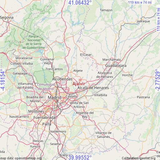
Ajalvir GPS coordinates[2]
40° 31' 55.38" North, 3° 28' 42.276" West
| Map corner | latitude | longitude |
|---|---|---|
| Upper-left | 41.06432°, | -4.18154° |
| Center: | 40.53205°, | -3.47841° |
| Lower-right: | 39.99552°, | -2.77529° |
| Map W x H: | 118.8×118.8 km | = 73.8×73.8mi |
| max Lat: | 43.74134° ⇑61.2% North |
| Ajalvir: | 40.53205° |
| min Lat: | ⇓38.8% South 27.64134° |
| min Long | Ajalvir | max Long |
| -18.00367° | -3.47841° | 4.2899° |
| W 48.2%⇐ | ⇒51.8% E |
Elevation
Elevation of Ajalvir is 666 m = 2185 ft, and this is 68 m = 223 ft above average elevation for this country.
| Max E: |
1682 m = 5518 ft | 49.3% |
| Ajalvir | 666 m 2185 ft | |
| Avg. | 598 m = 1962 ft | |
Min E: |
0 m = 0 ft | 50.7% |
See also: Spain elevation on elevation.city.
Geographical zone
Ajalvir is located in North temperate zone (between Tropic of Cancer and the Arctic Circle). Distance of this Northern Tropic circle is 1900.8 km =1181.1 mi to South.| Distance of | km | miles | from Ajalvir |
|---|---|---|---|
| North Pole | 5500.3 | 3417.7 | to North |
| Arctic Circle | 2894.4 | 1798.5 | to North |
| Tropic Cancer | 1900.8 | 1181.1 | to South |
| Equator | 4506.7 | 2800.3 | to South |


Nearby cities:
15 places around Ajalvir: (largest is in red/bold)
• Alcalá de Henares
11.5 km =7.1 mi,  119°
119°
• Algete
7.4 km =4.6 mi,  347°
347°
• Barajas de Madrid
10.6 km =6.6 mi,  232°
232°
• Camarma de Esteruelas
9.1 km =5.7 mi,  77°
77°
• Cobeña
4.3 km =2.7 mi,  334°
334°
• Coslada
13.9 km =8.6 mi,  210°
210°
• Daganzo de Arriba
2.3 km =1.4 mi,  59°
59°
• Fresno de Torote
8.7 km =5.4 mi,  41°
41°
• Fuente el Saz
11.5 km =7.1 mi, 345°
• Meco
12.8 km =8 mi, 79°
• Paracuellos de Jarama
5.2 km =3.2 mi, 232°
• San Fernando de Henares
12.9 km =8 mi,  200°
200°
• San Sebastián de los Reyes
12.9 km =8 mi,  281°
281°
• Torrejón de Ardoz
8.6 km =5.3 mi,  175°
175°
• Valdeolmos
11.9 km =7.4 mi,  11°
11°
Sources, notices
• [Note1] Compared only with cities in Spain existing in our database
• [Src1] Map data: © OpenStreetMap contributors (CC-BY-SA)
• [Src2] Other city data from geonames.org with taken over terms of usage.
• [Src3] Geographical zone / Annual Mean Temperature by Robert A. Rohde @ Wikipedia
