Cobeña geodata
Cobeña (Madrid) is a seat of a third-order administrative division; located in Spain in Europe/Madrid (GMT+2) time zone. With population of 3,933 people, there are 1493 cities with bigger population in this country. Compared to other cities in Spain, 60.5% of cities are located further ↑North; 52.1% of cities are located further →East and 52.3% of cities have lower elevation than Cobeña. Note1


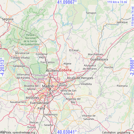
Cobeña GPS coordinates[2]
40° 34' 0.012" North, 3° 30' 0" West
| Map corner | latitude | longitude |
|---|---|---|
| Upper-left | 41.09867°, | -4.20313° |
| Center: | 40.56667°, | -3.5° |
| Lower-right: | 40.03041°, | -2.79688° |
| Map W x H: | 118.8×118.8 km | = 73.8×73.8mi |
| max Lat: | 43.74134° ⇑60.5% North |
| Cobeña: | 40.56667° |
| min Lat: | ⇓39.5% South 27.64134° |
| min Long | Cobeña | max Long |
| -18.00367° | -3.5° | 4.2899° |
| W 47.9%⇐ | ⇒52.1% E |
Elevation
Elevation of Cobeña is 682 m = 2238 ft, and this is 84 m = 276 ft above average elevation for this country.
| Max E: |
1682 m = 5518 ft | 47.7% |
| Cobeña | 682 m 2238 ft | |
| Avg. | 598 m = 1962 ft | |
Min E: |
0 m = 0 ft | 52.3% |
See also: Spain elevation on elevation.city.
Geographical zone
Cobeña is located in North temperate zone (between Tropic of Cancer and the Arctic Circle). Distance of this Northern Tropic circle is 1904.7 km =1183.5 mi to South.| Distance of | km | miles | from Cobeña |
|---|---|---|---|
| North Pole | 5496.5 | 3415.4 | to North |
| Arctic Circle | 2890.6 | 1796.1 | to North |
| Tropic Cancer | 1904.7 | 1183.5 | to South |
| Equator | 4510.6 | 2802.8 | to South |


Nearby cities:
15 places around Cobeña: (largest is in red/bold)
• Ajalvir
4.3 km =2.7 mi,  154°
154°
• Alcobendas
12.2 km =7.6 mi,  259°
259°
• Algete
3.4 km =2.1 mi,  3°
3°
• Barajas de Madrid
12.3 km =7.6 mi,  212°
212°
• Camarma de Esteruelas
10.9 km =6.8 mi,  99°
99°
• Daganzo de Arriba
4.7 km =2.9 mi,  124°
124°
• Fresno de Torote
8 km =5 mi,  70°
70°
• Fuente el Saz
7.3 km =4.5 mi,  352°
352°
• Meco
14.5 km =9 mi, 96°
• Paracuellos de Jarama
7.4 km =4.6 mi,  198°
198°
• Ribatejada
14.3 km =8.9 mi,  40°
40°
• San Sebastián de los Reyes
10.8 km =6.7 mi, 263°
• Torrejón de Ardoz
12.6 km =7.8 mi,  168°
168°
• Valdeolmos
8.9 km =5.5 mi,  28°
28°
• Valdetorres de Jarama
14.2 km =8.8 mi,  356°
356°
Sources, notices
• [Note1] Compared only with cities in Spain existing in our database
• [Src1] Map data: © OpenStreetMap contributors (CC-BY-SA)
• [Src2] Other city data from geonames.org with taken over terms of usage.
• [Src3] Geographical zone / Annual Mean Temperature by Robert A. Rohde @ Wikipedia
