Sitges geodata
Sitges (Catalonia) is a seat of a third-order administrative division; located in Spain in Europe/Madrid (GMT+2) time zone. With population of 27,668 people, there are 337 cities with bigger population in this country. Compared to other cities in Spain, 54.1% of cities are located further ↓South; 92.6% of cities are located further ←West and 96.4% of cities have higher elevation than Sitges. Note1


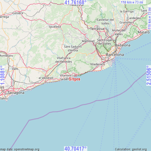
Sitges GPS coordinates[2]
41° 14' 6.216" North, 1° 48' 42.948" East
| Map corner | latitude | longitude |
|---|---|---|
| Upper-left | 41.76168°, | 1.10881° |
| Center: | 41.23506°, | 1.81193° |
| Lower-right: | 40.70417°, | 2.51506° |
| Map W x H: | 117.6×117.6 km | = 73.1×73.1mi |
| max Lat: | 43.74134° ⇑45.9% North |
| Sitges: | 41.23506° |
| min Lat: | ⇓54.1% South 27.64134° |
| min Long | Sitges | max Long |
| -18.00367° | 1.81193° | 4.2899° |
| W 92.6%⇐ | ⇒7.4% E |
Elevation
Elevation of Sitges is 18 m = 59 ft, and this is 580 m = 1903 ft below average elevation for this country.
| Max E: |
1682 m = 5518 ft | 96.4% |
| Avg. | 598 m = 1962 ft | |
| Sitges | 18 m = 59 ft | |
Min E: |
0 m = 0 ft | 3.6% |
See also: Spain elevation on elevation.city.
Geographical zone
Sitges is located in North temperate zone (between Tropic of Cancer and the Arctic Circle). Distance of this Northern Tropic circle is 1979 km =1229.7 mi to South.| Distance of | km | miles | from Sitges |
|---|---|---|---|
| North Pole | 5422.2 | 3369.2 | to North |
| Arctic Circle | 2816.3 | 1750 | to North |
| Tropic Cancer | 1979 | 1229.7 | to South |
| Equator | 4584.9 | 2848.9 | to South |


Nearby cities:
15 places around Sitges: (largest is in red/bold)
• Avinyonet del Penedès
13 km =8.1 mi,  349°
349°
• Begues
14.9 km =9.3 mi,  42°
42°
• Castelldefels
14.1 km =8.8 mi,  70°
70°
• Castellet
15.2 km =9.4 mi,  281°
281°
• Cubelles
12 km =7.5 mi,  255°
255°
• Cunit
15.2 km =9.4 mi,  254°
254°
• Gavà
17.7 km =11 mi,  63°
63°
• La Granada
17.7 km =11 mi,  334°
334°
• Olesa de Bonesvalls
13.6 km =8.5 mi,  13°
13°
• Olivella
9.1 km =5.7 mi,  2°
2°
• Sant Pere Molanta
13.9 km =8.6 mi, 334°
• Sant Pere de Ribes
4.3 km =2.7 mi,  311°
311°
• Subirats
18.4 km =11.4 mi, 5°
• Vilafranca del Penedès
15.6 km =9.7 mi,  322°
322°
• Vilanova i la Geltrú
7.4 km =4.6 mi, 260°
Sources, notices
• [Note1] Compared only with cities in Spain existing in our database
• [Src1] Map data: © OpenStreetMap contributors (CC-BY-SA)
• [Src2] Other city data from geonames.org with taken over terms of usage.
• [Src3] Geographical zone / Annual Mean Temperature by Robert A. Rohde @ Wikipedia
