Begonte geodata
Begonte (Galicia) is a seat of a third-order administrative division; located in Spain in Europe/Madrid (GMT+2) time zone. With population of 3,675 people, there are 1544 cities with bigger population in this country. Compared to other cities in Spain, 95.9% of cities are located further ↓South; 95.7% of cities are located further →East and 69.1% of cities have higher elevation than Begonte. Note1


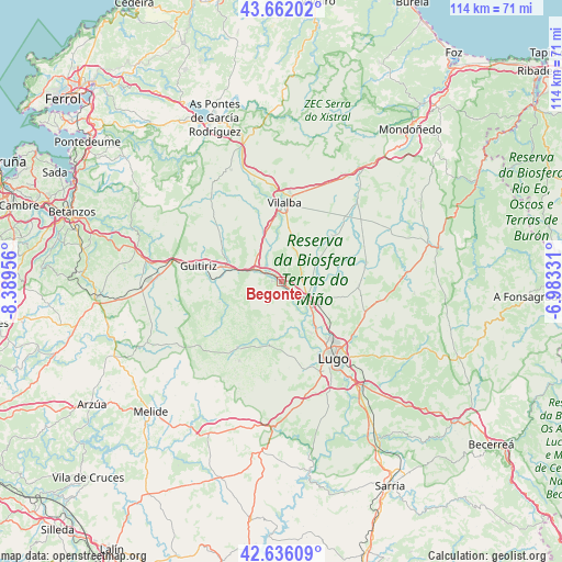
Begonte GPS coordinates[2]
43° 9' 4.356" North, 7° 41' 11.148" West
| Map corner | latitude | longitude |
|---|---|---|
| Upper-left | 43.66202°, | -8.38956° |
| Center: | 43.15121°, | -7.68643° |
| Lower-right: | 42.63609°, | -6.98331° |
| Map W x H: | 114.1×114.1 km | = 70.9×70.9mi |
| max Lat: | 43.74134° ⇑4.1% North |
| Begonte: | 43.15121° |
| min Lat: | ⇓95.9% South 27.64134° |
| min Long | Begonte | max Long |
| -18.00367° | -7.68643° | 4.2899° |
| W 4.3%⇐ | ⇒95.7% E |
Elevation
Elevation of Begonte is 397 m = 1302 ft, and this is 201 m = 659 ft below average elevation for this country.
| Max E: |
1682 m = 5518 ft | 69.1% |
| Avg. | 598 m = 1962 ft | |
| Begonte | 397 m = 1302 ft | |
Min E: |
0 m = 0 ft | 30.9% |
See also: Spain elevation on elevation.city.
Geographical zone
Begonte is located in North temperate zone (between Tropic of Cancer and the Arctic Circle). Distance of this Northern Tropic circle is 2192 km =1362 mi to South.| Distance of | km | miles | from Begonte |
|---|---|---|---|
| North Pole | 5209.1 | 3236.8 | to North |
| Arctic Circle | 2603.2 | 1617.6 | to North |
| Tropic Cancer | 2192 | 1362 | to South |
| Equator | 4798 | 2981.3 | to South |


Nearby cities:
15 places around Begonte: (largest is in red/bold)
• Abadín
29.1 km =18.1 mi,  34°
34°
• Aranga
28.4 km =17.6 mi,  289°
289°
• Castro de Rei
24.1 km =15 mi,  74°
74°
• Corgo
31 km =19.3 mi,  137°
137°
• Friol
15.9 km =9.9 mi,  213°
213°
• Guitiriz
17.4 km =10.8 mi,  281°
281°
• Guntín
29.4 km =18.3 mi,  180°
180°
• Lugo
18.9 km =11.7 mi,  146°
146°
• Mos
11 km =6.8 mi,  86°
86°
• Ourol
31.8 km =19.8 mi,  169°
169°
• Outeiro de Rei
8 km =5 mi,  133°
133°
• Pol
28.9 km =18 mi, 90°
• Rábade
6.8 km =4.2 mi,  124°
124°
• Sobrado
30.4 km =18.9 mi,  245°
245°
• Vilalba
16.3 km =10.1 mi,  1°
1°
Sources, notices
• [Note1] Compared only with cities in Spain existing in our database
• [Src1] Map data: © OpenStreetMap contributors (CC-BY-SA)
• [Src2] Other city data from geonames.org with taken over terms of usage.
• [Src3] Geographical zone / Annual Mean Temperature by Robert A. Rohde @ Wikipedia
