Lerga geodata
Lerga (Navarre) is a seat of a third-order administrative division; located in Spain in Europe/Madrid (GMT+2) time zone. With population of 75 people, there are 6194 cities with bigger population in this country. Compared to other cities in Spain, 88.7% of cities are located further ↓South; 72.9% of cities are located further ←West and 53.5% of cities have higher elevation than Lerga. Note1


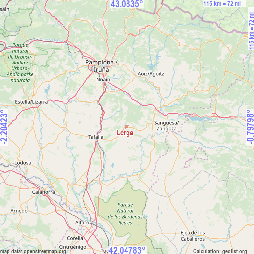
Lerga GPS coordinates[2]
42° 34' 4.116" North, 1° 30' 3.96" West
| Map corner | latitude | longitude |
|---|---|---|
| Upper-left | 43.0835°, | -2.20423° |
| Center: | 42.56781°, | -1.5011° |
| Lower-right: | 42.04783°, | -0.79798° |
| Map W x H: | 115.2×115.2 km | = 71.6×71.6mi |
| max Lat: | 43.74134° ⇑11.3% North |
| Lerga: | 42.56781° |
| min Lat: | ⇓88.7% South 27.64134° |
| min Long | Lerga | max Long |
| -18.00367° | -1.5011° | 4.2899° |
| W 72.9%⇐ | ⇒27.1% E |
Elevation
Elevation of Lerga is 618 m = 2028 ft, and this is 20 m = 66 ft above average elevation for this country.
| Max E: |
1682 m = 5518 ft | 53.5% |
| Lerga | 618 m 2028 ft | |
| Avg. | 598 m = 1962 ft | |
Min E: |
0 m = 0 ft | 46.5% |
See also: Spain elevation on elevation.city.
Geographical zone
Lerga is located in North temperate zone (between Tropic of Cancer and the Arctic Circle). Distance of this Northern Tropic circle is 2127.2 km =1321.8 mi to South.| Distance of | km | miles | from Lerga |
|---|---|---|---|
| North Pole | 5274 | 3277.1 | to North |
| Arctic Circle | 2668.1 | 1657.9 | to North |
| Tropic Cancer | 2127.2 | 1321.8 | to South |
| Equator | 4733.1 | 2941 | to South |


Nearby cities:
15 places around Lerga: (largest is in red/bold)
• Barásoain
12.5 km =7.8 mi,  288°
288°
• Cáseda
12.1 km =7.5 mi,  114°
114°
• Eslava
3.4 km =2.1 mi,  95°
95°
• Gallipienzo
8.8 km =5.5 mi,  123°
123°
• Garínoain
12.3 km =7.6 mi, 287°
• Leache
8.8 km =5.5 mi,  60°
60°
• Monreal
15.2 km =9.4 mi,  357°
357°
• Olóriz
11.8 km =7.3 mi,  309°
309°
• Orísoain
9.2 km =5.7 mi, 293°
• Pueyo
12.1 km =7.5 mi,  268°
268°
• San Martín de Unx
6.9 km =4.3 mi,  225°
225°
• Tafalla
14.9 km =9.3 mi,  252°
252°
• Ujué
7.5 km =4.7 mi,  179°
179°
• Unzué
13.9 km =8.6 mi, 312°
• Áibar
11.8 km =7.3 mi,  76°
76°
Sources, notices
• [Note1] Compared only with cities in Spain existing in our database
• [Src1] Map data: © OpenStreetMap contributors (CC-BY-SA)
• [Src2] Other city data from geonames.org with taken over terms of usage.
• [Src3] Geographical zone / Annual Mean Temperature by Robert A. Rohde @ Wikipedia
