Ávila geodata
Ávila (Castille and León) is a seat of a second-order administrative division; located in Spain in Europe/Madrid (GMT+2) time zone. With population of 56,855 people, there are 164 cities with bigger population in this country. Compared to other cities in Spain, 58.7% of cities are located further ↑North; 68.7% of cities are located further →East and 94.6% of cities have lower elevation than Ávila. Note1


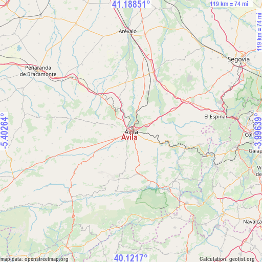
Ávila GPS coordinates[2]
40° 39' 26.064" North, 4° 41' 58.236" West
| Map corner | latitude | longitude |
|---|---|---|
| Upper-left | 41.18851°, | -5.40264° |
| Center: | 40.65724°, | -4.69951° |
| Lower-right: | 40.1217°, | -3.99639° |
| Map W x H: | 118.6×118.6 km | = 73.7×73.7mi |
| max Lat: | 43.74134° ⇑58.7% North |
| Ávila: | 40.65724° |
| min Lat: | ⇓41.3% South 27.64134° |
| min Long | Ávila | max Long |
| -18.00367° | -4.69951° | 4.2899° |
| W 31.3%⇐ | ⇒68.7% E |
Elevation
Elevation of Ávila is 1127 m = 3698 ft, and this is 529 m = 1736 ft above average elevation for this country.
| Max E: |
1682 m = 5518 ft | 5.4% |
| Ávila | 1127 m 3698 ft | |
| Avg. | 598 m = 1962 ft | |
Min E: |
0 m = 0 ft | 94.6% |
See also: Ávila elevation on elevation.city.
Geographical zone
Ávila is located in North temperate zone (between Tropic of Cancer and the Arctic Circle). Distance of this Northern Tropic circle is 1914.7 km =1189.7 mi to South.| Distance of | km | miles | from Ávila |
|---|---|---|---|
| North Pole | 5486.4 | 3409.1 | to North |
| Arctic Circle | 2880.5 | 1789.9 | to North |
| Tropic Cancer | 1914.7 | 1189.7 | to South |
| Equator | 4520.7 | 2809 | to South |


Nearby cities:
15 places around Ávila: (largest is in red/bold)
• Berrocalejo de Aragona
9.8 km =6.1 mi,  64°
64°
• Cardeñosa
10.2 km =6.3 mi,  337°
337°
• Gemuño
10.1 km =6.3 mi,  223°
223°
• Martiherrero
7.2 km =4.5 mi,  285°
285°
• Mediana de Voltoya
12.5 km =7.8 mi,  67°
67°
• Mingorría
10.9 km =6.8 mi,  15°
15°
• Monsalupe
14.3 km =8.9 mi,  331°
331°
• Muñopepe
10.4 km =6.5 mi,  255°
255°
• Niharra
14 km =8.7 mi,  237°
237°
• Padiernos
12.9 km =8 mi,  252°
252°
• Peñalba de Ávila
13.4 km =8.3 mi, 343°
• Salobral
10.6 km =6.6 mi, 241°
• San Esteban de los Patos
11.8 km =7.3 mi,  32°
32°
• Tolbaños
14.4 km =8.9 mi,  43°
43°
• Tornadizos de Ávila
7.9 km =4.9 mi,  114°
114°
Sources, notices
• [Note1] Compared only with cities in Spain existing in our database
• [Src1] Map data: © OpenStreetMap contributors (CC-BY-SA)
• [Src2] Other city data from geonames.org with taken over terms of usage.
• [Src3] Geographical zone / Annual Mean Temperature by Robert A. Rohde @ Wikipedia
