Friol geodata
Friol (Galicia) is a seat of a third-order administrative division; located in Spain in Europe/Madrid (GMT+2) time zone. With population of 4,522 people, there are 1380 cities with bigger population in this country. Compared to other cities in Spain, 94.6% of cities are located further ↓South; 95.9% of cities are located further →East and 63.6% of cities have higher elevation than Friol. Note1


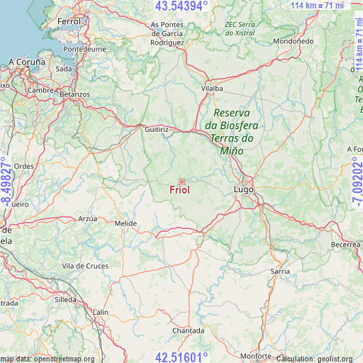
Friol GPS coordinates[2]
43° 1' 55.668" North, 7° 47' 42.504" West
| Map corner | latitude | longitude |
|---|---|---|
| Upper-left | 43.54394°, | -8.49827° |
| Center: | 43.03213°, | -7.79514° |
| Lower-right: | 42.51601°, | -7.09202° |
| Map W x H: | 114.3×114.3 km | = 71×71mi |
| max Lat: | 43.74134° ⇑5.4% North |
| Friol: | 43.03213° |
| min Lat: | ⇓94.6% South 27.64134° |
| min Long | Friol | max Long |
| -18.00367° | -7.79514° | 4.2899° |
| W 4.1%⇐ | ⇒95.9% E |
Elevation
Elevation of Friol is 478 m = 1568 ft, and this is 120 m = 394 ft below average elevation for this country.
| Max E: |
1682 m = 5518 ft | 63.6% |
| Avg. | 598 m = 1962 ft | |
| Friol | 478 m = 1568 ft | |
Min E: |
0 m = 0 ft | 36.4% |
See also: Spain elevation on elevation.city.
Geographical zone
Friol is located in North temperate zone (between Tropic of Cancer and the Arctic Circle). Distance of this Northern Tropic circle is 2178.8 km =1353.8 mi to South.| Distance of | km | miles | from Friol |
|---|---|---|---|
| North Pole | 5222.3 | 3245 | to North |
| Arctic Circle | 2616.4 | 1625.8 | to North |
| Tropic Cancer | 2178.8 | 1353.8 | to South |
| Equator | 4784.7 | 2973.1 | to South |


Nearby cities:
15 places around Friol: (largest is in red/bold)
• Aranga
28.8 km =17.9 mi,  321°
321°
• Begonte
15.9 km =9.9 mi,  33°
33°
• Boimorto
27.7 km =17.2 mi,  262°
262°
• Guitiriz
18.6 km =11.6 mi,  333°
333°
• Guntín
18.2 km =11.3 mi,  152°
152°
• Lugo
19.6 km =12.2 mi,  97°
97°
• Melide
22.2 km =13.8 mi,  233°
233°
• Monterroso
26.8 km =16.7 mi,  186°
186°
• Mos
24.2 km =15 mi,  55°
55°
• Ourol
23.3 km =14.5 mi,  140°
140°
• Outeiro de Rei
16.6 km =10.3 mi, 62°
• Rábade
17.3 km =10.7 mi, 56°
• Santiso
27.5 km =17.1 mi, 230°
• Sobrado
18.9 km =11.7 mi,  272°
272°
• Vilasantar
26.9 km =16.7 mi,  279°
279°
Sources, notices
• [Note1] Compared only with cities in Spain existing in our database
• [Src1] Map data: © OpenStreetMap contributors (CC-BY-SA)
• [Src2] Other city data from geonames.org with taken over terms of usage.
• [Src3] Geographical zone / Annual Mean Temperature by Robert A. Rohde @ Wikipedia
