Beriáin geodata
Beriáin (Navarre) is a seat of a third-order administrative division; located in Spain in Europe/Madrid (GMT+2) time zone. With population of 3,156 people, there are 1675 cities with bigger population in this country. Compared to other cities in Spain, 92% of cities are located further ↓South; 71.5% of cities are located further ←West and 62.3% of cities have higher elevation than Beriáin. Note1


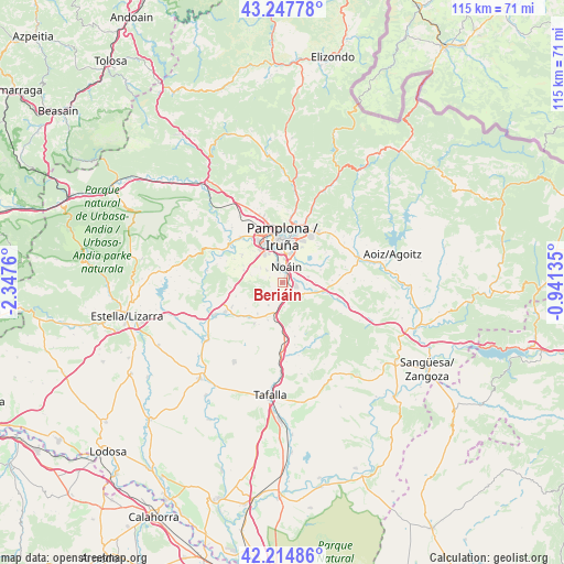
Beriáin GPS coordinates[2]
42° 44' 0.492" North, 1° 38' 40.128" West
| Map corner | latitude | longitude |
|---|---|---|
| Upper-left | 43.24778°, | -2.3476° |
| Center: | 42.73347°, | -1.64448° |
| Lower-right: | 42.21486°, | -0.94135° |
| Map W x H: | 114.8×114.8 km | = 71.3×71.3mi |
| max Lat: | 43.74134° ⇑8% North |
| Beriáin: | 42.73347° |
| min Lat: | ⇓92% South 27.64134° |
| min Long | Beriáin | max Long |
| -18.00367° | -1.64448° | 4.2899° |
| W 71.5%⇐ | ⇒28.5% E |
Elevation
Elevation of Beriáin is 495 m = 1624 ft, and this is 103 m = 338 ft below average elevation for this country.
| Max E: |
1682 m = 5518 ft | 62.3% |
| Avg. | 598 m = 1962 ft | |
| Beriáin | 495 m = 1624 ft | |
Min E: |
0 m = 0 ft | 37.7% |
See also: Spain elevation on elevation.city.
Geographical zone
Beriáin is located in North temperate zone (between Tropic of Cancer and the Arctic Circle). Distance of this Northern Tropic circle is 2145.6 km =1333.2 mi to South.| Distance of | km | miles | from Beriáin |
|---|---|---|---|
| North Pole | 5255.5 | 3265.6 | to North |
| Arctic Circle | 2649.7 | 1646.4 | to North |
| Tropic Cancer | 2145.6 | 1333.2 | to South |
| Equator | 4751.5 | 2952.4 | to South |


Nearby cities:
15 places around Beriáin: (largest is in red/bold)
• Adiós
9.1 km =5.7 mi,  234°
234°
• Barañáin
8.5 km =5.3 mi,  341°
341°
• Cizur Mayor
7.1 km =4.4 mi,  328°
328°
• Elorz
6.8 km =4.2 mi,  90°
90°
• Enériz
9.7 km =6 mi,  224°
224°
• Ermitagaña
8.8 km =5.5 mi,  349°
349°
• Galar
5.4 km =3.4 mi,  305°
305°
• Iturrama
8.4 km =5.2 mi, 352°
• Pamplona
9.3 km =5.8 mi,  0°
0°
• Primer Ensanche
9.1 km =5.7 mi,  357°
357°
• Sarriguren
9.6 km =6 mi,  23°
23°
• Segundo Ensanche
8.9 km =5.5 mi, 0°
• Tirapu
9.7 km =6 mi,  209°
209°
• Unzué
9.1 km =5.7 mi,  170°
170°
• Uterga
9.8 km =6.1 mi,  254°
254°
Sources, notices
• [Note1] Compared only with cities in Spain existing in our database
• [Src1] Map data: © OpenStreetMap contributors (CC-BY-SA)
• [Src2] Other city data from geonames.org with taken over terms of usage.
• [Src3] Geographical zone / Annual Mean Temperature by Robert A. Rohde @ Wikipedia
