Camarasa geodata
Camarasa (Catalonia) is a seat of a third-order administrative division; located in Spain in Europe/Madrid (GMT+2) time zone. With population of 916 people, there are 3056 cities with bigger population in this country. Compared to other cities in Spain, 70.4% of cities are located further ↓South; 90.1% of cities are located further ←West and 75.3% of cities have higher elevation than Camarasa. Note1


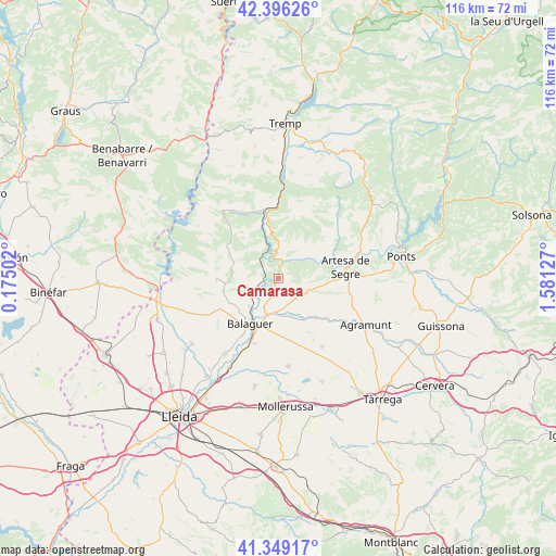
Camarasa GPS coordinates[2]
41° 52' 29.496" North, 0° 52' 41.304" East
| Map corner | latitude | longitude |
|---|---|---|
| Upper-left | 42.39626°, | 0.17502° |
| Center: | 41.87486°, | 0.87814° |
| Lower-right: | 41.34917°, | 1.58127° |
| Map W x H: | 116.4×116.4 km | = 72.3×72.3mi |
| max Lat: | 43.74134° ⇑29.6% North |
| Camarasa: | 41.87486° |
| min Lat: | ⇓70.4% South 27.64134° |
| min Long | Camarasa | max Long |
| -18.00367° | 0.87814° | 4.2899° |
| W 90.1%⇐ | ⇒9.9% E |
Elevation
Elevation of Camarasa is 294 m = 965 ft, and this is 304 m = 997 ft below average elevation for this country.
| Max E: |
1682 m = 5518 ft | 75.3% |
| Avg. | 598 m = 1962 ft | |
| Camarasa | 294 m = 965 ft | |
Min E: |
0 m = 0 ft | 24.7% |
See also: Spain elevation on elevation.city.
Geographical zone
Camarasa is located in North temperate zone (between Tropic of Cancer and the Arctic Circle). Distance of this Northern Tropic circle is 2050.1 km =1273.9 mi to South.| Distance of | km | miles | from Camarasa |
|---|---|---|---|
| North Pole | 5351 | 3325 | to North |
| Arctic Circle | 2745.1 | 1705.7 | to North |
| Tropic Cancer | 2050.1 | 1273.9 | to South |
| Equator | 4656 | 2893.1 | to South |


Nearby cities:
15 places around Camarasa: (largest is in red/bold)
• Artesa de Segre
14.1 km =8.8 mi,  81°
81°
• Balaguer
10.8 km =6.7 mi,  210°
210°
• Bellcaire d'Urgell
14.2 km =8.8 mi,  167°
167°
• Castellserà
17.2 km =10.7 mi,  143°
143°
• Castelló de Farfanya
13.6 km =8.5 mi,  241°
241°
• Cubells
7.2 km =4.5 mi,  111°
111°
• Linyola
19.7 km =12.2 mi, 170°
• Menàrguens
19 km =11.8 mi, 214°
• Montgai
11.1 km =6.9 mi, 138°
• Os de Balaguer
13.1 km =8.1 mi,  269°
269°
• Penelles
15.7 km =9.8 mi,  152°
152°
• Preixens
16.7 km =10.4 mi,  121°
121°
• Térmens
19.9 km =12.4 mi, 207°
• Vallfogona de Balaguer
14.7 km =9.1 mi,  201°
201°
• Àger
16.7 km =10.4 mi,  326°
326°
Sources, notices
• [Note1] Compared only with cities in Spain existing in our database
• [Src1] Map data: © OpenStreetMap contributors (CC-BY-SA)
• [Src2] Other city data from geonames.org with taken over terms of usage.
• [Src3] Geographical zone / Annual Mean Temperature by Robert A. Rohde @ Wikipedia
