Artajona geodata
Artajona (Navarre) is a seat of a third-order administrative division; located in Spain in Europe/Madrid (GMT+2) time zone. With population of 1,639 people, there are 2378 cities with bigger population in this country. Compared to other cities in Spain, 89.2% of cities are located further ↓South; 69.9% of cities are located further ←West and 68.4% of cities have higher elevation than Artajona. Note1


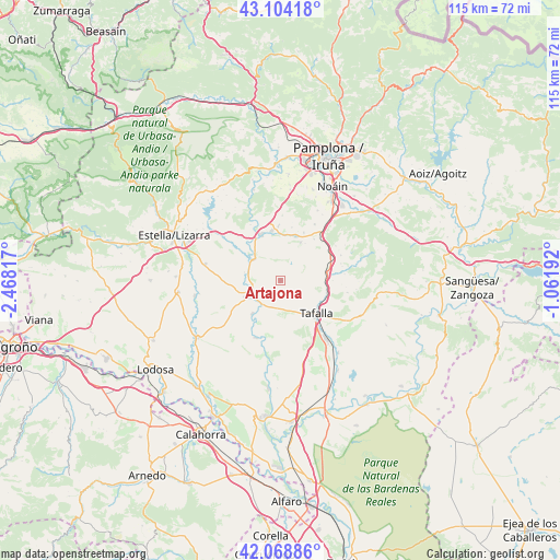
Artajona GPS coordinates[2]
42° 35' 19.212" North, 1° 45' 54.144" West
| Map corner | latitude | longitude |
|---|---|---|
| Upper-left | 43.10418°, | -2.46817° |
| Center: | 42.58867°, | -1.76504° |
| Lower-right: | 42.06886°, | -1.06192° |
| Map W x H: | 115.1×115.1 km | = 71.5×71.5mi |
| max Lat: | 43.74134° ⇑10.8% North |
| Artajona: | 42.58867° |
| min Lat: | ⇓89.2% South 27.64134° |
| min Long | Artajona | max Long |
| -18.00367° | -1.76504° | 4.2899° |
| W 69.9%⇐ | ⇒30.1% E |
Elevation
Elevation of Artajona is 410 m = 1345 ft, and this is 188 m = 617 ft below average elevation for this country.
| Max E: |
1682 m = 5518 ft | 68.4% |
| Avg. | 598 m = 1962 ft | |
| Artajona | 410 m = 1345 ft | |
Min E: |
0 m = 0 ft | 31.6% |
See also: Spain elevation on elevation.city.
Geographical zone
Artajona is located in North temperate zone (between Tropic of Cancer and the Arctic Circle). Distance of this Northern Tropic circle is 2129.5 km =1323.2 mi to South.| Distance of | km | miles | from Artajona |
|---|---|---|---|
| North Pole | 5271.6 | 3275.6 | to North |
| Arctic Circle | 2665.8 | 1656.5 | to North |
| Tropic Cancer | 2129.5 | 1323.2 | to South |
| Equator | 4735.4 | 2942.4 | to South |


Nearby cities:
15 places around Artajona: (largest is in red/bold)
• Adiós
11.1 km =6.9 mi,  12°
12°
• Añorbe
8.7 km =5.4 mi,  28°
28°
• Barásoain
9.8 km =6.1 mi,  80°
80°
• Berbinzana
8.8 km =5.5 mi,  219°
219°
• Enériz
9.6 km =6 mi,  18°
18°
• Garínoain
10 km =6.2 mi, 82°
• Larraga
7.7 km =4.8 mi,  244°
244°
• Mañeru
12.1 km =7.5 mi,  318°
318°
• Mendigorría
7.2 km =4.5 mi,  307°
307°
• Muruzábal
11.3 km =7 mi,  358°
358°
• Obanos
10.4 km =6.5 mi,  350°
350°
• Puente la Reina
10.2 km =6.3 mi,  336°
336°
• Pueyo
9.9 km =6.2 mi,  105°
105°
• Tafalla
10.1 km =6.3 mi,  132°
132°
• Tirapu
9.2 km =5.7 mi, 33°
Sources, notices
• [Note1] Compared only with cities in Spain existing in our database
• [Src1] Map data: © OpenStreetMap contributors (CC-BY-SA)
• [Src2] Other city data from geonames.org with taken over terms of usage.
• [Src3] Geographical zone / Annual Mean Temperature by Robert A. Rohde @ Wikipedia
