Pueyo geodata
Pueyo (Navarre) is a seat of a third-order administrative division; located in Spain in Europe/Madrid (GMT+2) time zone. With population of 321 people, there are 4419 cities with bigger population in this country. Compared to other cities in Spain, 88.6% of cities are located further ↓South; 71.4% of cities are located further ←West and 59.5% of cities have higher elevation than Pueyo. Note1


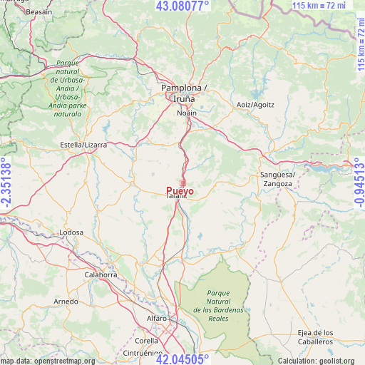
Pueyo GPS coordinates[2]
42° 33' 54.216" North, 1° 38' 53.736" West
| Map corner | latitude | longitude |
|---|---|---|
| Upper-left | 43.08077°, | -2.35138° |
| Center: | 42.56506°, | -1.64826° |
| Lower-right: | 42.04505°, | -0.94513° |
| Map W x H: | 115.2×115.2 km | = 71.6×71.6mi |
| max Lat: | 43.74134° ⇑11.4% North |
| Pueyo: | 42.56506° |
| min Lat: | ⇓88.6% South 27.64134° |
| min Long | Pueyo | max Long |
| -18.00367° | -1.64826° | 4.2899° |
| W 71.4%⇐ | ⇒28.6% E |
Elevation
Elevation of Pueyo is 533 m = 1749 ft, and this is 65 m = 213 ft below average elevation for this country.
| Max E: |
1682 m = 5518 ft | 59.5% |
| Avg. | 598 m = 1962 ft | |
| Pueyo | 533 m = 1749 ft | |
Min E: |
0 m = 0 ft | 40.5% |
See also: Spain elevation on elevation.city.
Geographical zone
Pueyo is located in North temperate zone (between Tropic of Cancer and the Arctic Circle). Distance of this Northern Tropic circle is 2126.9 km =1321.6 mi to South.| Distance of | km | miles | from Pueyo |
|---|---|---|---|
| North Pole | 5274.3 | 3277.3 | to North |
| Arctic Circle | 2668.4 | 1658.1 | to North |
| Tropic Cancer | 2126.9 | 1321.6 | to South |
| Equator | 4732.8 | 2940.8 | to South |


Nearby cities:
15 places around Pueyo: (largest is in red/bold)
• Artajona
9.9 km =6.2 mi,  285°
285°
• Añorbe
11.6 km =7.2 mi,  332°
332°
• Barásoain
4.3 km =2.7 mi,  1°
1°
• Beire
12.5 km =7.8 mi,  169°
169°
• Enériz
13.5 km =8.4 mi, 331°
• Garínoain
3.9 km =2.4 mi, 4°
• Lerga
12.1 km =7.5 mi,  88°
88°
• Olite
9.5 km =5.9 mi,  181°
181°
• Olóriz
8.3 km =5.2 mi,  20°
20°
• Orísoain
5.4 km =3.4 mi,  42°
42°
• San Martín de Unx
8.4 km =5.2 mi,  122°
122°
• Tafalla
4.8 km =3 mi,  206°
206°
• Tirapu
11.2 km =7 mi,  336°
336°
• Ujué
14.1 km =8.8 mi, 120°
• Unzué
9.9 km =6.2 mi,  10°
10°
Sources, notices
• [Note1] Compared only with cities in Spain existing in our database
• [Src1] Map data: © OpenStreetMap contributors (CC-BY-SA)
• [Src2] Other city data from geonames.org with taken over terms of usage.
• [Src3] Geographical zone / Annual Mean Temperature by Robert A. Rohde @ Wikipedia
