Ontígola geodata
Ontígola (Castille-La Mancha) is a seat of a third-order administrative division; located in Spain in Europe/Madrid (GMT+2) time zone. With population of 1,965 people, there are 2197 cities with bigger population in this country. Compared to other cities in Spain, 70.2% of cities are located further ↑North; 53.2% of cities are located further →East and 54% of cities have higher elevation than Ontígola. Note1
Administrative division(s):
- Level 1: Castille-La Mancha
- Level 2: Province of Toledo
- Level 3: Ontígola


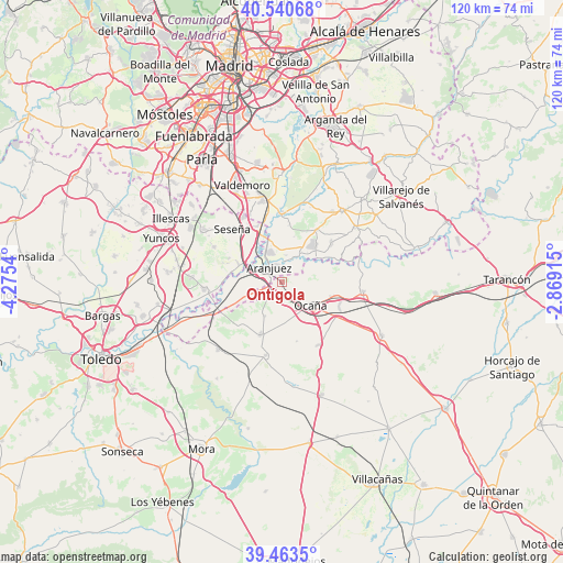
Ontígola GPS coordinates[2]
40° 0' 15.156" North, 3° 34' 20.172" West
| Map corner | latitude | longitude |
|---|---|---|
| Upper-left | 40.54068°, | -4.2754° |
| Center: | 40.00421°, | -3.57227° |
| Lower-right: | 39.4635°, | -2.86915° |
| Map W x H: | 119.8×119.8 km | = 74.4×74.4mi |
| max Lat: | 43.74134° ⇑70.2% North |
| Ontígola: | 40.00421° |
| min Lat: | ⇓29.8% South 27.64134° |
| min Long | Ontígola | max Long |
| -18.00367° | -3.57227° | 4.2899° |
| W 46.8%⇐ | ⇒53.2% E |
Elevation
Elevation of Ontígola is 612 m = 2008 ft, and this is 14 m = 46 ft above average elevation for this country.
| Max E: |
1682 m = 5518 ft | 54% |
| Ontígola | 612 m 2008 ft | |
| Avg. | 598 m = 1962 ft | |
Min E: |
0 m = 0 ft | 46% |
See also: Spain elevation on elevation.city.
Geographical zone
Ontígola is located in North temperate zone (between Tropic of Cancer and the Arctic Circle). Distance of this Northern Tropic circle is 1842.1 km =1144.6 mi to South.| Distance of | km | miles | from Ontígola |
|---|---|---|---|
| North Pole | 5559 | 3454.2 | to North |
| Arctic Circle | 2953.1 | 1835 | to North |
| Tropic Cancer | 1842.1 | 1144.6 | to South |
| Equator | 4448.1 | 2763.9 | to South |


Nearby cities:
15 places around Ontígola: (largest is in red/bold)
• Aranjuez
3.9 km =2.4 mi,  319°
319°
• Añover de Tajo
16.6 km =10.3 mi,  264°
264°
• Borox
15.8 km =9.8 mi,  296°
296°
• Cabañas de Yepes
13 km =8.1 mi,  165°
165°
• Ciempozuelos
17.7 km =11 mi,  346°
346°
• Ciruelos
8.1 km =5 mi,  205°
205°
• Dosbarrios
15.5 km =9.6 mi,  151°
151°
• Huerta de Valdecarábanos
16.1 km =10 mi,  192°
192°
• Noblejas
11.6 km =7.2 mi,  103°
103°
• Ocaña
8.1 km =5 mi,  129°
129°
• Seseña
15.5 km =9.6 mi, 316°
• Titulcia
14.6 km =9.1 mi,  1°
1°
• Villaconejos
13.2 km =8.2 mi,  35°
35°
• Villarrubia de Santiago
17.4 km =10.8 mi, 96°
• Yepes
12.2 km =7.6 mi,  201°
201°
Sources, notices
• [Note1] Compared only with cities in Spain existing in our database
• [Src1] Map data: © OpenStreetMap contributors (CC-BY-SA)
• [Src2] Other city data from geonames.org with taken over terms of usage.
• [Src3] Geographical zone / Annual Mean Temperature by Robert A. Rohde @ Wikipedia
