Ocaña geodata
Ocaña (Castille-La Mancha) is a seat of a third-order administrative division; located in Spain in Europe/Madrid (GMT+2) time zone. With population of 6,913 people, there are 1045 cities with bigger population in this country. Compared to other cities in Spain, 70.9% of cities are located further ↑North; 52.1% of cities are located further →East and 59.5% of cities have lower elevation than Ocaña. Note1


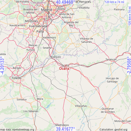
Ocaña GPS coordinates[2]
39° 57' 28.26" North, 3° 29' 53.52" West
| Map corner | latitude | longitude |
|---|---|---|
| Upper-left | 40.49468°, | -4.20133° |
| Center: | 39.95785°, | -3.4982° |
| Lower-right: | 39.41677°, | -2.79508° |
| Map W x H: | 119.9×119.9 km | = 74.5×74.5mi |
| max Lat: | 43.74134° ⇑70.9% North |
| Ocaña: | 39.95785° |
| min Lat: | ⇓29.1% South 27.64134° |
| min Long | Ocaña | max Long |
| -18.00367° | -3.4982° | 4.2899° |
| W 47.9%⇐ | ⇒52.1% E |
Elevation
Elevation of Ocaña is 741 m = 2431 ft, and this is 143 m = 469 ft above average elevation for this country.
| Max E: |
1682 m = 5518 ft | 40.5% |
| Ocaña | 741 m 2431 ft | |
| Avg. | 598 m = 1962 ft | |
Min E: |
0 m = 0 ft | 59.5% |
See also: Spain elevation on elevation.city.
Geographical zone
Ocaña is located in North temperate zone (between Tropic of Cancer and the Arctic Circle). Distance of this Northern Tropic circle is 1837 km =1141.5 mi to South.| Distance of | km | miles | from Ocaña |
|---|---|---|---|
| North Pole | 5564.2 | 3457.4 | to North |
| Arctic Circle | 2958.3 | 1838.2 | to North |
| Tropic Cancer | 1837 | 1141.5 | to South |
| Equator | 4442.9 | 2760.7 | to South |


Nearby cities:
15 places around Ocaña: (largest is in red/bold)
• Aranjuez
12 km =7.5 mi,  312°
312°
• Cabañas de Yepes
8.1 km =5 mi,  202°
202°
• Chinchón
21.3 km =13.2 mi,  17°
17°
• Ciruelos
10.1 km =6.3 mi,  257°
257°
• Colmenar de Oreja
19.1 km =11.9 mi,  30°
30°
• Dosbarrios
8.5 km =5.3 mi,  171°
171°
• Huerta de Valdecarábanos
14.4 km =8.9 mi,  222°
222°
• La Guardia
19 km =11.8 mi, 174°
• Noblejas
5.6 km =3.5 mi,  62°
62°
• Ontígola
8.1 km =5 mi, 309°
• Titulcia
20.6 km =12.8 mi,  343°
343°
• Villaconejos
16 km =9.9 mi,  4°
4°
• Villarrubia de Santiago
11.4 km =7.1 mi,  74°
74°
• Villatobas
16.1 km =10 mi,  112°
112°
• Yepes
12.5 km =7.8 mi,  240°
240°
Sources, notices
• [Note1] Compared only with cities in Spain existing in our database
• [Src1] Map data: © OpenStreetMap contributors (CC-BY-SA)
• [Src2] Other city data from geonames.org with taken over terms of usage.
• [Src3] Geographical zone / Annual Mean Temperature by Robert A. Rohde @ Wikipedia
