Noblejas geodata
Noblejas (Castille-La Mancha) is a seat of a third-order administrative division; located in Spain in Europe/Madrid (GMT+2) time zone. With population of 3,322 people, there are 1630 cities with bigger population in this country. Compared to other cities in Spain, 70.5% of cities are located further ↑North; 51.3% of cities are located further →East and 59.9% of cities have lower elevation than Noblejas. Note1
Administrative division(s):
- Level 1: Castille-La Mancha
- Level 2: Province of Toledo
- Level 3: Noblejas


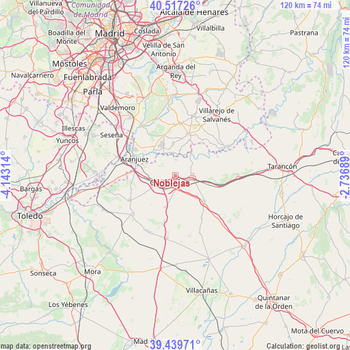
Noblejas GPS coordinates[2]
39° 58' 50.196" North, 3° 26' 24.036" West
| Map corner | latitude | longitude |
|---|---|---|
| Upper-left | 40.51726°, | -4.14314° |
| Center: | 39.98061°, | -3.44001° |
| Lower-right: | 39.43971°, | -2.73689° |
| Map W x H: | 119.8×119.8 km | = 74.4×74.4mi |
| max Lat: | 43.74134° ⇑70.5% North |
| Noblejas: | 39.98061° |
| min Lat: | ⇓29.5% South 27.64134° |
| min Long | Noblejas | max Long |
| -18.00367° | -3.44001° | 4.2899° |
| W 48.7%⇐ | ⇒51.3% E |
Elevation
Elevation of Noblejas is 744 m = 2441 ft, and this is 146 m = 479 ft above average elevation for this country.
| Max E: |
1682 m = 5518 ft | 40.1% |
| Noblejas | 744 m 2441 ft | |
| Avg. | 598 m = 1962 ft | |
Min E: |
0 m = 0 ft | 59.9% |
See also: Spain elevation on elevation.city.
Geographical zone
Noblejas is located in North temperate zone (between Tropic of Cancer and the Arctic Circle). Distance of this Northern Tropic circle is 1839.5 km =1143 mi to South.| Distance of | km | miles | from Noblejas |
|---|---|---|---|
| North Pole | 5561.6 | 3455.8 | to North |
| Arctic Circle | 2955.7 | 1836.6 | to North |
| Tropic Cancer | 1839.5 | 1143 | to South |
| Equator | 4445.4 | 2762.2 | to South |


Nearby cities:
15 places around Noblejas: (largest is in red/bold)
• Aranjuez
14.9 km =9.3 mi,  292°
292°
• Belmonte de Tajo
19 km =11.8 mi,  27°
27°
• Cabañas de Yepes
12.9 km =8 mi,  218°
218°
• Chinchón
17.8 km =11.1 mi,  4°
4°
• Ciruelos
15.5 km =9.6 mi,  252°
252°
• Colmenar de Oreja
14.8 km =9.2 mi,  18°
18°
• Dosbarrios
11.6 km =7.2 mi,  198°
198°
• Huerta de Valdecarábanos
19.7 km =12.2 mi,  228°
228°
• Ocaña
5.6 km =3.5 mi,  242°
242°
• Ontígola
11.6 km =7.2 mi,  283°
283°
• Villaconejos
13.9 km =8.6 mi,  344°
344°
• Villamanrique de Tajo
19.8 km =12.3 mi,  61°
61°
• Villarrubia de Santiago
6.1 km =3.8 mi,  84°
84°
• Villatobas
13.2 km =8.2 mi,  131°
131°
• Yepes
18 km =11.2 mi, 241°
Sources, notices
• [Note1] Compared only with cities in Spain existing in our database
• [Src1] Map data: © OpenStreetMap contributors (CC-BY-SA)
• [Src2] Other city data from geonames.org with taken over terms of usage.
• [Src3] Geographical zone / Annual Mean Temperature by Robert A. Rohde @ Wikipedia
